
Odda topographic map
Interactive map
Click on the map to display elevation.
About this map
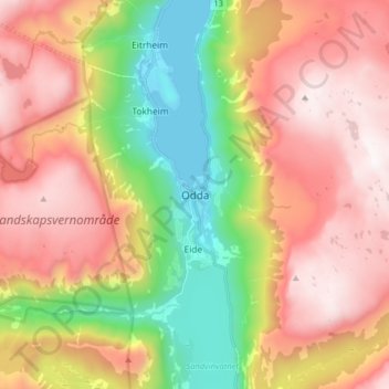
Name: Odda topographic map, elevation, terrain.
Location: Odda, Ullensvang, Vestland, 5750, Norway (60.02792 6.50693 60.10792 6.58693)
Average elevation: 2,503 ft
Minimum elevation: 0 ft
Maximum elevation: 4,879 ft
Other topographic maps
Click on a map to view its topography, its elevation and its terrain.
Vinjane
Norway > Vestland > Aurlandsvangen
Vinjane, Aurlandsvangen, Aurland, Vestland, 5745, Norway
Average elevation: 758 ft
Strandebarm
Strandebarm, Kvam herad, Vestland, 5630, Norway
Average elevation: 594 ft