
Holly River State Park topographic map
Interactive map
Click on the map to display elevation.
About this map
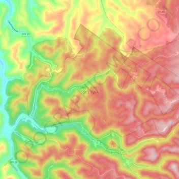
Name: Holly River State Park topographic map, elevation, terrain.
Average elevation: 2,211 ft
Minimum elevation: 1,348 ft
Maximum elevation: 2,917 ft
Other topographic maps
Click on a map to view its topography, its elevation and its terrain.
Hacker Valley
United States > West Virginia > Webster County
Hacker Valley, Webster County, West Virginia, 26222, United States
Average elevation: 1,909 ft
Cowen
United States > West Virginia > Webster County
Cowen, Webster County, West Virginia, 26206, United States
Average elevation: 2,326 ft
Addison (Webster Springs)
United States > West Virginia > Webster County
Addison (Webster Springs), Webster County, West Virginia, 26288, United States
Average elevation: 1,975 ft
Big Ditch Lake
United States > West Virginia > Webster County
Big Ditch Lake, Webster County, West Virginia, United States
Average elevation: 2,323 ft