
Rileyville topographic map
Interactive map
Click on the map to display elevation.
About this map
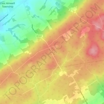
Name: Rileyville topographic map, elevation, terrain.
Average elevation: 410 ft
Minimum elevation: 177 ft
Maximum elevation: 584 ft
Other topographic maps
Click on a map to view its topography, its elevation and its terrain.
Bowne
United States > New Jersey > Hunterdon County > East Amwell Township
Bowne, East Amwell Township, Hunterdon County, New Jersey, United States
Average elevation: 243 ft
Linvale
United States > New Jersey > Hunterdon County > East Amwell Township
Linvale, East Amwell Township, Hunterdon County, New Jersey, United States
Average elevation: 358 ft
Larisons Corners
United States > New Jersey > Hunterdon County > East Amwell Township
Larisons Corners, East Amwell Township, Hunterdon County, New Jersey, 08551, United States
Average elevation: 217 ft
Snydertown
United States > New Jersey > Hunterdon County > East Amwell Township
Snydertown, East Amwell Township, Hunterdon County, New Jersey, 08551, United States
Average elevation: 361 ft
Wertsville
United States > New Jersey > Hunterdon County > East Amwell Township
Wertsville, East Amwell Township, Hunterdon County, New Jersey, United States
Average elevation: 236 ft
Ringoes
United States > New Jersey > Hunterdon County > East Amwell Township
Ringoes, East Amwell Township, Hunterdon County, New Jersey, 08551, United States
Average elevation: 246 ft