
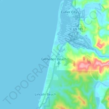
Lincoln Beach topographic map
Interactive map
Click on the map to display elevation.
About this map
Name: Lincoln Beach topographic map, elevation, terrain.
Location: Lincoln Beach, Lincoln County, Oregon, United States (44.83856 -124.05423 44.92652 -124.00564)
Average elevation: 98 ft
Minimum elevation: -10 ft
Maximum elevation: 981 ft
Lincoln Beach is located in northwestern Lincoln County at 44°52′20″N 124°02′12″W / 44.872092°N 124.036591°W / 44.872092; -124.036591, between Lincoln City to the north and Depoe Bay to the south. It is bordered to the west by the Pacific Ocean. Lincoln Beach proper is in the southern part of the CDP at 46 feet (14 m) above sea level, while Gleneden Beach is in the northern part of the CDP at an elevation of 40 feet (12 m). U.S. Route 101 runs through the CDP, leading north 8 miles (13 km) to the center of Lincoln City and south 17 miles (27 km) to Newport, the Lincoln county seat.
Other topographic maps
Click on a map to view its topography, its elevation and its terrain.
Newport
United States > Oregon > Lincoln County
Newport, Lincoln County, Oregon, United States
Average elevation: 108 ft
Lincoln City
United States > Oregon > Lincoln County
Lincoln City, Lincoln County, Oregon, United States
Average elevation: 154 ft
Otis
United States > Oregon > Lincoln County
Otis, Lincoln County, Oregon, 97368, United States
Average elevation: 243 ft
Waldport
United States > Oregon > Lincoln County
Waldport, Lincoln County, Oregon, 97394, United States
Average elevation: 69 ft
Yachats
United States > Oregon > Lincoln County
Yachats, Lincoln County, Oregon, United States
Average elevation: 174 ft
Drift Creek
United States > Oregon > Lincoln County
Drift Creek, Lincoln County, Oregon, United States
Average elevation: 308 ft
Bayview
United States > Oregon > Lincoln County
Bayview, Lincoln County, Oregon, 97394, United States
Average elevation: 128 ft
Yaquina Head Light
United States > Oregon > Lincoln County > Newport
Yaquina Head Light, Lighthouse Trail, Newport, Lincoln County, Oregon, 97365, United States
Average elevation: 20 ft
Otter Rock
United States > Oregon > Lincoln County
Otter Rock, Lincoln County, Oregon, 97369, United States
Average elevation: 174 ft
Burnt Woods
United States > Oregon > Lincoln County
Burnt Woods, Lincoln County, Oregon, 96326, United States
Average elevation: 883 ft
Tidewater
United States > Oregon > Lincoln County
Tidewater, Lincoln County, Oregon, 97390, United States
Average elevation: 728 ft
Seal Rock
United States > Oregon > Lincoln County
Seal Rock, Lincoln County, Oregon, 97376, United States
Average elevation: 69 ft
Depoe Bay
United States > Oregon > Lincoln County
Depoe Bay, Lincoln County, Oregon, United States
Average elevation: 157 ft
Beverly Beach
United States > Oregon > Lincoln County
Beverly Beach, Lincoln County, Oregon, 97369, United States
Average elevation: 95 ft
Toledo
United States > Oregon > Lincoln County
Toledo, Lincoln County, Oregon, 97391, United States
Average elevation: 121 ft
Yaquina Bay
United States > Oregon > Lincoln County > Newport
Yaquina Bay, Newport, Lincoln County, Oregon, 97365, United States
Average elevation: 75 ft
Siletz
United States > Oregon > Lincoln County
Siletz, Lincoln County, Oregon, 97380, United States
Average elevation: 174 ft
Boiler Bay
United States > Oregon > Lincoln County
Boiler Bay, Lincoln County, Oregon, 97341, United States
Average elevation: 98 ft
Agate Beach
United States > Oregon > Lincoln County > Newport
Agate Beach, Newport, Lincoln County, Oregon, 97365, United States
Average elevation: 138 ft