
Fjærland topographic map
Interactive map
Click on the map to display elevation.
About this map
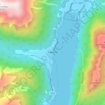
Name: Fjærland topographic map, elevation, terrain.
Location: Fjærland, Sogndal, Vestland, 6848, Norway (61.38427 6.72010 61.42427 6.76010)
Average elevation: 1,188 ft
Minimum elevation: 0 ft
Maximum elevation: 4,236 ft
Other topographic maps
Click on a map to view its topography, its elevation and its terrain.
Vinjane
Norway > Vestland > Aurlandsvangen
Vinjane, Aurlandsvangen, Aurland, Vestland, 5745, Norway
Average elevation: 758 ft
Strandebarm
Strandebarm, Kvam herad, Vestland, 5630, Norway
Average elevation: 594 ft