
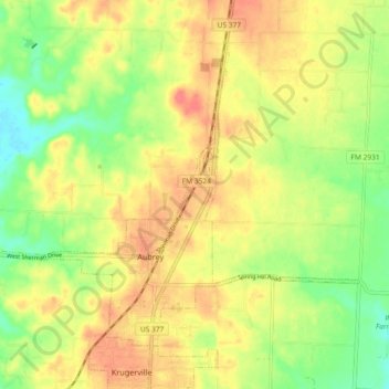
Aubrey topographic map
Interactive map
Click on the map to display elevation.
About this map
Name: Aubrey topographic map, elevation, terrain.
Location: Aubrey, Denton County, Texas, United States (33.28671 -97.02849 33.34634 -96.93673)
Average elevation: 646 ft
Minimum elevation: 548 ft
Maximum elevation: 732 ft
Other topographic maps
Click on a map to view its topography, its elevation and its terrain.
Denton
United States > Texas > Denton County
Denton, Denton County, Texas, United States
Average elevation: 640 ft
Roanoke
United States > Texas > Denton County
Roanoke, Denton County, Texas, 76262, United States
Average elevation: 610 ft
Lakewood Village
United States > Texas > Denton County
Lakewood Village, Denton County, Texas, United States
Average elevation: 531 ft
Krum
United States > Texas > Denton County
Krum, Denton County, Texas, United States
Average elevation: 719 ft
Providence Village
United States > Texas > Denton County
Providence Village, Denton County, Texas, 76227, United States
Average elevation: 584 ft
Hickory Creek
United States > Texas > Denton County
Hickory Creek, Denton County, Texas, United States
Average elevation: 554 ft
Double Oak
United States > Texas > Denton County
Double Oak, Denton County, Texas, United States
Average elevation: 646 ft
Plainview
United States > Texas > Denton County
Plainview, Denton County, Texas, United States
Average elevation: 814 ft
Bartonville
United States > Texas > Denton County
Bartonville, Denton County, Texas, United States
Average elevation: 650 ft
Navo
United States > Texas > Denton County
Navo, Denton County, Texas, 75068, United States
Average elevation: 558 ft
Bolivar
United States > Texas > Denton County > Sanger
Bolivar, Sanger, Denton County, Texas, United States
Average elevation: 702 ft
Drop
United States > Texas > Denton County
Drop, Denton County, Texas, United States
Average elevation: 732 ft
Mustang
United States > Texas > Denton County
Mustang, Denton County, Texas, United States
Average elevation: 597 ft
Cross Roads
United States > Texas > Denton County
Cross Roads, Denton County, Texas, United States
Average elevation: 564 ft
Hackberry
United States > Texas > Denton County
Hackberry, Denton County, Texas, United States
Average elevation: 548 ft
Cooper Creek
United States > Texas > Denton County > Denton
Cooper Creek, Denton, Denton County, Texas, 76298, United States
Average elevation: 604 ft
Stony
United States > Texas > Denton County
Stony, Denton County, Texas, United States
Average elevation: 787 ft
Hebron
United States > Texas > Denton County
Hebron, Denton County, Texas, United States
Average elevation: 627 ft
Mingo
United States > Texas > Denton County > Denton
Mingo, Denton, Denton County, Texas, 76298, United States
Average elevation: 564 ft
Paloma Creek South HOA Playground
United States > Texas > Denton County > Navo
Paloma Creek South HOA Playground, Navo, Denton County, Texas, United States
Average elevation: 558 ft
Green Valley
United States > Texas > Denton County > Denton
Green Valley, Denton, Denton County, Texas, United States
Average elevation: 591 ft
Draper
United States > Texas > Denton County
Draper, Denton County, Texas, United States
Average elevation: 699 ft
Lewisville Lake
United States > Texas > Denton County > Oak Point
Lewisville Lake, Oak Point, Denton County, Texas, 75068, United States
Average elevation: 554 ft
North Pointe Park
United States > Texas > Denton County > Denton
North Pointe Park, Denton, Denton County, Texas, 76201, United States
Average elevation: 689 ft
Krugerville
United States > Texas > Denton County
Krugerville, Denton County, Texas, United States
Average elevation: 669 ft
Fort Worth
United States > Texas > Denton County
Fort Worth, Denton County, Texas, United States
Average elevation: 699 ft
Flower Mound
United States > Texas > Denton County
Flower Mound, Denton County, Texas, United States
Average elevation: 584 ft
Little Elm
United States > Texas > Denton County
Little Elm, Denton County, Texas, 75068, United States
Average elevation: 561 ft
Nix Slough
United States > Texas > Denton County
Nix Slough, Denton County, Texas, 75068, United States
Average elevation: 541 ft
Oak Point
United States > Texas > Denton County
Oak Point, Denton County, Texas, United States
Average elevation: 561 ft
Pilot Point
United States > Texas > Denton County
Pilot Point, Denton County, Texas, 76258, United States
Average elevation: 650 ft
Sanger
United States > Texas > Denton County
Sanger, Denton County, Texas, 76266, United States
Average elevation: 686 ft
Corinth
United States > Texas > Denton County
Corinth, Denton County, Texas, 76210, United States
Average elevation: 591 ft
Northlake
United States > Texas > Denton County
Northlake, Denton County, Texas, United States
Average elevation: 666 ft
Trophy Club
United States > Texas > Denton County
Trophy Club, Denton County, Texas, United States
Average elevation: 614 ft
Ponder
United States > Texas > Denton County
Ponder, Denton County, Texas, 76259, United States
Average elevation: 738 ft
Sanger
United States > Texas > Denton County > Sanger > Sanger
Sanger, Denton County, Texas, 76266, United States
Average elevation: 673 ft
The Colony
United States > Texas > Denton County
The Colony, Denton County, Texas, 75056, United States
Average elevation: 574 ft
Justin
United States > Texas > Denton County
Justin, Denton County, Texas, United States
Average elevation: 650 ft
Westlake
United States > Texas > Denton County
Westlake, Denton County, Texas, United States
Average elevation: 653 ft
Shady Shores
United States > Texas > Denton County
Shady Shores, Denton County, Texas, United States
Average elevation: 541 ft
Lewisville
United States > Texas > Denton County > Lewisville
Lewisville, Denton County, Texas, 75067, United States
Average elevation: 571 ft
Argyle
United States > Texas > Denton County
Argyle, Denton County, Texas, United States
Average elevation: 676 ft
South Lakes Park
United States > Texas > Denton County > Denton
South Lakes Park, Denton, Denton County, Texas, 76205, United States
Average elevation: 659 ft
DISH
United States > Texas > Denton County
DISH, Denton County, Texas, United States
Average elevation: 659 ft
Copper Canyon
United States > Texas > Denton County
Copper Canyon, Denton County, Texas, United States
Average elevation: 604 ft
Highland Village
United States > Texas > Denton County
Highland Village, Denton County, Texas, 75077, United States
Average elevation: 558 ft
Lewisville
United States > Texas > Denton County
Lewisville, Denton County, Texas, United States
Average elevation: 525 ft
Lake Dallas
United States > Texas > Denton County
Lake Dallas, Denton County, Texas, 75065, United States
Average elevation: 554 ft
Parvin
United States > Texas > Denton County > Prosper
Parvin, Prosper, Denton County, Texas, United States
Average elevation: 591 ft