
Make a donation
Gear up for your next adventure:
As an Amazon Associate, this site earns from qualifying purchases at no extra cost to you.
Esteli topographic map
Click on the map to display elevation.
Make a donation
Gear up for your next adventure:
As an Amazon Associate, this site earns from qualifying purchases at no extra cost to you.
Esteli
Located on the Pan-American Highway, 150 km north of Managua, Estelí is a fast-growing and progressive city. It enjoys a pleasant climate most of the year due to its location in the north central highlands at a mean elevation of 844 m (2769 ft) above sea level. The city is also surrounded by forested mountains of pines, oaks, and walnuts, and plateaus up to 1600 m above sea level, some of which are protected as natural reserves.
Make a donation
Gear up for your next adventure:
As an Amazon Associate, this site earns from qualifying purchases at no extra cost to you.
About this map
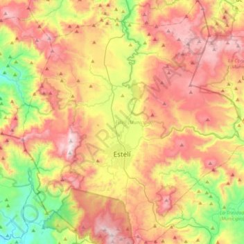
Name: Esteli topographic map, elevation, terrain.
Location: Esteli, Estelí, 31000, Nicaragua (12.97287 -86.49200 13.30004 -86.16472)
Average elevation: 3,143 ft
Minimum elevation: 1,168 ft
Maximum elevation: 5,194 ft
Make a donation
Gear up for your next adventure:
As an Amazon Associate, this site earns from qualifying purchases at no extra cost to you.
Other topographic maps
Click on a map to view its topography, its elevation and its terrain.