
Four Points topographic map
Interactive map
Click on the map to display elevation.
About this map
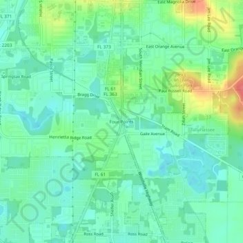
Name: Four Points topographic map, elevation, terrain.
Average elevation: 79 ft
Minimum elevation: 16 ft
Maximum elevation: 223 ft
Other topographic maps
Click on a map to view its topography, its elevation and its terrain.
Saint Peter
United States > Florida > Leon County > Tallahassee
Saint Peter, Tallahassee, Leon County, Florida, 32308, United States
Average elevation: 161 ft
Tallahassee
United States > Florida > Leon County > Tallahassee
Tallahassee, Leon County, Florida, 32399-1300, United States
Average elevation: 105 ft
Cascades Park
United States > Florida > Leon County > Tallahassee
Cascades Park, Tallahassee, Leon County, Florida, 32301, United States
Average elevation: 161 ft
Henrietta
United States > Florida > Leon County > Tallahassee > Henrietta
Henrietta, Tallahassee, Leon County, Florida, 32313, United States
Average elevation: 66 ft