
Hillsborough topographic map
Interactive map
Click on the map to display elevation.
About this map
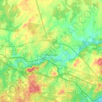
Name: Hillsborough topographic map, elevation, terrain.
Average elevation: 614 ft
Minimum elevation: 456 ft
Maximum elevation: 823 ft
Other topographic maps
Click on a map to view its topography, its elevation and its terrain.
Chapel Hill
United States > North Carolina > Orange County
Chapel Hill, Orange County, North Carolina, United States
Average elevation: 413 ft
Lake Michie
United States > North Carolina > Orange County > McDade
Lake Michie, McDade, Orange County, North Carolina, United States
Average elevation: 702 ft
Plantation Acres
United States > North Carolina > Orange County > Carrboro
Plantation Acres, Carrboro, Orange County, North Carolina, 27516, United States
Average elevation: 476 ft
Elkins Hills
United States > North Carolina > Orange County > Chapel Hill
Elkins Hills, Chapel Hill, Orange County, North Carolina, 27515, United States
Average elevation: 449 ft
Fox Meadows
United States > North Carolina > Orange County > Carrboro
Fox Meadows, Carrboro, Orange County, North Carolina, 27510, United States
Average elevation: 525 ft
Timbercrest
United States > North Carolina > Orange County
Timbercrest, Orange County, North Carolina, 27514, United States
Average elevation: 358 ft
Carrboro
United States > North Carolina > Orange County
Carrboro, Orange County, North Carolina, 27510, United States
Average elevation: 456 ft
Dodsons Crossroads
United States > North Carolina > Orange County
Dodsons Crossroads, Orange County, North Carolina, United States
Average elevation: 614 ft
High Park
United States > North Carolina > Orange County > Chapel Hill
High Park, Chapel Hill, Orange County, North Carolina, 27599, United States
Average elevation: 420 ft
Bolin Creek
United States > North Carolina > Orange County > Chapel Hill
Bolin Creek, Bolin, Chapel Hill, Orange County, North Carolina, 27515, United States
Average elevation: 430 ft
Baby Hollow
United States > North Carolina > Orange County > Chapel Hill
Baby Hollow, Chapel Hill, Orange County, North Carolina, 27599, United States
Average elevation: 381 ft
Efland
United States > North Carolina > Orange County
Efland, Orange County, North Carolina, 27243, United States
Average elevation: 633 ft