
Make a donation
Gear up for your next adventure:
As an Amazon Associate, this site earns from qualifying purchases at no extra cost to you.
Beveren topographic map
Click on the map to display elevation.
Make a donation
Gear up for your next adventure:
As an Amazon Associate, this site earns from qualifying purchases at no extra cost to you.
Beveren
Beveren bevindt zich in Zandlemig Vlaanderen op een hoogte van ongeveer 20 meter. De belangrijkste beek is de Krommebeek die zuidwaarts naar de Mandel stroomt. De omgeving van Beveren is sterk verstedelijkt, vooral naar het westen toe.
Make a donation
Gear up for your next adventure:
As an Amazon Associate, this site earns from qualifying purchases at no extra cost to you.
About this map
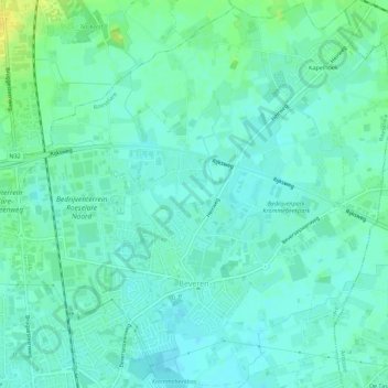
Name: Beveren topographic map, elevation, terrain.
Location: Beveren, Roeselare, West-Vlaanderen, België (50.95948 3.11722 50.99396 3.17268)
Average elevation: 79 ft
Minimum elevation: 56 ft
Maximum elevation: 128 ft
Make a donation
Gear up for your next adventure:
As an Amazon Associate, this site earns from qualifying purchases at no extra cost to you.
Other topographic maps
Click on a map to view its topography, its elevation and its terrain.