
Make a donation
Gear up for your next adventure:
As an Amazon Associate, this site earns from qualifying purchases at no extra cost to you.
Otanche topographic map
Click on the map to display elevation.
Make a donation
Gear up for your next adventure:
As an Amazon Associate, this site earns from qualifying purchases at no extra cost to you.
About this map
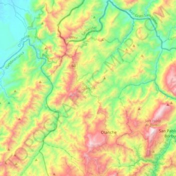
Name: Otanche topographic map, elevation, terrain.
Location: Otanche, Occidente, Boyacá, RAP (Especial) Central, Colombie (5.57642 -74.30717 5.91139 -74.07954)
Average elevation: 2,799 ft
Minimum elevation: 732 ft
Maximum elevation: 6,227 ft
Make a donation
Gear up for your next adventure:
As an Amazon Associate, this site earns from qualifying purchases at no extra cost to you.
Other topographic maps
Click on a map to view its topography, its elevation and its terrain.
Complejo de Páramo Altiplano Cundiboyacense
Colombie > Boyacá > Ventaquemada
Average elevation: 9,902 ft
Make a donation
Gear up for your next adventure:
As an Amazon Associate, this site earns from qualifying purchases at no extra cost to you.