
Carlisle Township topographic map
Interactive map
Click on the map to display elevation.
About this map
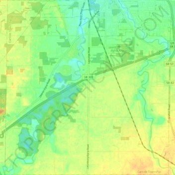
Name: Carlisle Township topographic map, elevation, terrain.
Location: Carlisle Township, Lorain County, Ohio, United States (41.27462 -82.16707 41.35232 -82.06912)
Average elevation: 771 ft
Minimum elevation: 722 ft
Maximum elevation: 817 ft
Other topographic maps
Click on a map to view its topography, its elevation and its terrain.
Columbia Township
United States > Ohio > Lorain County
Columbia Township, Lorain County, Ohio, 44028, United States
Average elevation: 817 ft
Grafton Township
United States > Ohio > Lorain County
Grafton Township, Lorain County, Ohio, United States
Average elevation: 869 ft
Lorain
United States > Ohio > Lorain County
Lorain, Lorain County, Ohio, United States
Average elevation: 630 ft
Vermilion River
United States > Ohio > Lorain County > Vermilion
Vermilion River, Vermilion, Brownhelm Township, Lorain County, Ohio, United States
Average elevation: 656 ft
Eaton Estates
United States > Ohio > Lorain County > Eaton Estates
Eaton Estates, Eaton Township, Lorain County, Ohio, United States
Average elevation: 804 ft
Vermilion-on-the-Lake
United States > Ohio > Lorain County > Vermilion
Vermilion-on-the-Lake, Vermilion, Lorain County, Ohio, 44089, United States
Average elevation: 597 ft
Elyria
United States > Ohio > Lorain County
Elyria, Lorain County, Ohio, 44035, United States
Average elevation: 732 ft
Columbia Center
United States > Ohio > Lorain County
Columbia Center, Columbia Township, Lorain County, Ohio, 44028, United States
Average elevation: 801 ft
North Ridgeville
United States > Ohio > Lorain County
North Ridgeville, Lorain County, Ohio, 44039, United States
Average elevation: 738 ft
Grafton
United States > Ohio > Lorain County
Grafton, Lorain County, Ohio, United States
Average elevation: 804 ft
Wellington
United States > Ohio > Lorain County
Wellington, Lorain County, Ohio, United States
Average elevation: 860 ft
North Eaton
United States > Ohio > Lorain County
North Eaton, Eaton Township, Lorain County, Ohio, United States
Average elevation: 810 ft
Kingsleys Corners
United States > Ohio > Lorain County
Kingsleys Corners, Grafton Township, Lorain County, Ohio, 44044, United States
Average elevation: 840 ft
Sheffield
United States > Ohio > Lorain County > Sheffield
Sheffield, Lorain County, Ohio, 44054, United States
Average elevation: 627 ft
Avon
United States > Ohio > Lorain County
Avon, Lorain County, Ohio, 44011, United States
Average elevation: 663 ft
Oberlin
United States > Ohio > Lorain County
Oberlin, Lorain County, Ohio, 44074, United States
Average elevation: 814 ft
Columbia Station
United States > Ohio > Lorain County
Columbia Station, Columbia Township, Lorain County, Ohio, 44028, United States
Average elevation: 807 ft
Elyria
United States > Ohio > Lorain County > Elyria
Elyria, Lorain County, Ohio, 44035, United States
Average elevation: 732 ft
Amherst
United States > Ohio > Lorain County
Amherst, Lorain County, Ohio, 44001, United States
Average elevation: 682 ft
Huntington Township
United States > Ohio > Lorain County
Huntington Township, Lorain County, Ohio, United States
Average elevation: 974 ft
Avon Lake
United States > Ohio > Lorain County
Avon Lake, Lorain County, Ohio, 44012, United States
Average elevation: 607 ft