
Make a donation
Gear up for your next adventure:
As an Amazon Associate, this site earns from qualifying purchases at no extra cost to you.
Albardo topographic map
Click on the map to display elevation.
Make a donation
Gear up for your next adventure:
As an Amazon Associate, this site earns from qualifying purchases at no extra cost to you.
About this map
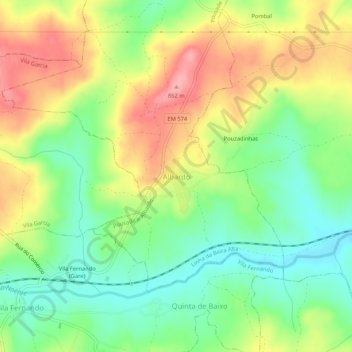
Name: Albardo topographic map, elevation, terrain.
Location: Albardo, Guarda, 6300-255, Portugal (40.48966 -7.15141 40.52966 -7.11141)
Average elevation: 2,615 ft
Minimum elevation: 2,454 ft
Maximum elevation: 2,812 ft
Make a donation
Gear up for your next adventure:
As an Amazon Associate, this site earns from qualifying purchases at no extra cost to you.
Other topographic maps
Click on a map to view its topography, its elevation and its terrain.
Fernão Joanes
Localiza-se a sudoeste da Guarda, a quase 1000 metros de altitude (950 metros) e possui um passado ligado à pastorícia. Hoje em dia há poucos rebanhos.
Average elevation: 2,874 ft
Make a donation
Gear up for your next adventure:
As an Amazon Associate, this site earns from qualifying purchases at no extra cost to you.
Make a donation
Gear up for your next adventure:
As an Amazon Associate, this site earns from qualifying purchases at no extra cost to you.