
Waldo Lake topographic map
Interactive map
Click on the map to display elevation.
About this map
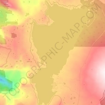
Name: Waldo Lake topographic map, elevation, terrain.
Location: Waldo Lake, Lane County, Oregon, United States (43.68100 -122.07040 43.76747 -122.00370)
Average elevation: 5,535 ft
Minimum elevation: 3,570 ft
Maximum elevation: 6,781 ft
Other topographic maps
Click on a map to view its topography, its elevation and its terrain.
Eugene
United States > Oregon > Lane County
Eugene, Lane County, Oregon, United States
Average elevation: 535 ft
Florence
United States > Oregon > Lane County
Florence, Lane County, Oregon, United States
Average elevation: 72 ft
Cheshire
United States > Oregon > Lane County > Cheshire
Cheshire, Lane County, Oregon, 97419, United States
Average elevation: 358 ft
Pleasant Hill
United States > Oregon > Lane County
Pleasant Hill, Lane County, Oregon, 97455, United States
Average elevation: 600 ft
Leaburg
United States > Oregon > Lane County
Leaburg, Lane County, Oregon, United States
Average elevation: 1,165 ft
Mapleton
United States > Oregon > Lane County
Mapleton, Lane County, Oregon, 97453, United States
Average elevation: 430 ft
McKenzie River
United States > Oregon > Lane County > Rainbow
McKenzie River, Rainbow, Lane County, Oregon, 97413, United States
Average elevation: 1,414 ft
Dorena Lake
United States > Oregon > Lane County
Dorena Lake, Lane County, Oregon, United States
Average elevation: 1,086 ft
Cheshire
United States > Oregon > Lane County
Cheshire, Lane County, Oregon, United States
Average elevation: 358 ft
Oakridge
United States > Oregon > Lane County
Oakridge, Lane County, Oregon, United States
Average elevation: 1,526 ft
Waldo Lake Wilderness
United States > Oregon > Lane County
Waldo Lake Wilderness, Lane County, Oregon, United States
Average elevation: 5,013 ft
Coburg
United States > Oregon > Lane County
Coburg, Lane County, Oregon, 97408, United States
Average elevation: 394 ft
Cottage Grove
United States > Oregon > Lane County
Cottage Grove, Lane County, Oregon, 97424, United States
Average elevation: 755 ft
Swisshome
United States > Oregon > Lane County
Swisshome, Lane County, Oregon, 97480, United States
Average elevation: 728 ft
McKenzie River
United States > Oregon > Lane County
McKenzie River, Lane County, Oregon, United States
Average elevation: 2,290 ft
Veneta
United States > Oregon > Lane County
Veneta, Lane County, Oregon, 97487, United States
Average elevation: 436 ft
Westfir
United States > Oregon > Lane County
Westfir, Lane County, Oregon, 47492, United States
Average elevation: 1,450 ft
Disston
United States > Oregon > Lane County
Disston, Lane County, Oregon, United States
Average elevation: 1,680 ft
Lowell
United States > Oregon > Lane County
Lowell, Lane County, Oregon, 97452, United States
Average elevation: 856 ft
Marcola
United States > Oregon > Lane County
Marcola, Lane County, Oregon, United States
Average elevation: 732 ft
Elmira
United States > Oregon > Lane County > Elmira
Elmira, Lane County, Oregon, United States
Average elevation: 394 ft
Washington/Jefferson City Park
United States > Oregon > Lane County > Eugene
Washington/Jefferson City Park, Eugene, Lane County, Oregon, United States
Average elevation: 427 ft
Rainbow
United States > Oregon > Lane County
Rainbow, Lane County, Oregon, 97413, United States
Average elevation: 1,594 ft
Noti
United States > Oregon > Lane County > Noti
Noti, Lane County, Oregon, 97461, United States
Average elevation: 659 ft
West Bank City Park
United States > Oregon > Lane County > Eugene
West Bank City Park, Bethel, Eugene, Lane County, Oregon, United States
Average elevation: 410 ft
Springfield
United States > Oregon > Lane County
Springfield, Lane County, Oregon, United States
Average elevation: 581 ft
Walton
United States > Oregon > Lane County
Walton, Lane County, Oregon, United States
Average elevation: 758 ft
Cupit Mary Mountain
United States > Oregon > Lane County
Cupit Mary Mountain, Lane County, Oregon, United States
Average elevation: 5,584 ft
Dorena
United States > Oregon > Lane County > Dorena
Dorena, Lane County, Oregon, 97434, United States
Average elevation: 1,424 ft
Culp Creek
United States > Oregon > Lane County > Culp Creek
Culp Creek, Lane County, Oregon, 97434, United States
Average elevation: 1,555 ft
Saddle Camp Butte
United States > Oregon > Lane County
Saddle Camp Butte, Lane County, Oregon, United States
Average elevation: 3,192 ft
Junction City
United States > Oregon > Lane County
Junction City, Lane County, Oregon, United States
Average elevation: 335 ft
McKenzie Bridge
United States > Oregon > Lane County
McKenzie Bridge, Lane County, Oregon, 97413, United States
Average elevation: 1,709 ft
Mount Popocatepetl
United States > Oregon > Lane County
Mount Popocatepetl, Lane County, Oregon, United States
Average elevation: 535 ft
Dexter
United States > Oregon > Lane County
Dexter, Lane County, Oregon, 97431, United States
Average elevation: 787 ft
Creswell
United States > Oregon > Lane County
Creswell, Lane County, Oregon, 97426, United States
Average elevation: 541 ft
Fuji Mountain
United States > Oregon > Lane County
Fuji Mountain, Lane County, Oregon, United States
Average elevation: 6,184 ft
Three Sisters Wilderness
United States > Oregon > Lane County
Three Sisters Wilderness, Lane County, Oregon, United States
Average elevation: 4,564 ft