
Sunrise Manor topographic map
Interactive map
Click on the map to display elevation.
About this map
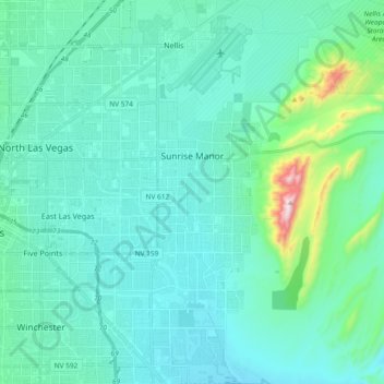
Name: Sunrise Manor topographic map, elevation, terrain.
Location: Sunrise Manor, Clark County, Nevada, United States (36.10758 -115.11614 36.25831 -114.98480)
Average elevation: 1,965 ft
Minimum elevation: 1,480 ft
Maximum elevation: 3,999 ft
Other topographic maps
Click on a map to view its topography, its elevation and its terrain.
Las Vegas
United States > Nevada > Clark County
Las Vegas, Clark County, Nevada, United States
Average elevation: 2,480 ft
Henderson
United States > Nevada > Clark County
Henderson, Clark County, Nevada, United States
Average elevation: 2,267 ft
Summerlin
United States > Nevada > Clark County > Las Vegas
Summerlin, Las Vegas, Clark County, Nevada, 89134, United States
Average elevation: 2,766 ft
Mesquite
United States > Nevada > Clark County
Mesquite, Clark County, Nevada, United States
Average elevation: 1,975 ft
Mount Charleston
United States > Nevada > Clark County
Mount Charleston, Clark County, Nevada, United States
Average elevation: 8,399 ft
Paradise
United States > Nevada > Clark County
Paradise, Clark County, Nevada, United States
Average elevation: 2,172 ft
Lake Mead
United States > Nevada > Clark County
Lake Mead, Clark County, Nevada, United States
Average elevation: 2,244 ft
Harris Mtn Trail
United States > Nevada > Clark County
Harris Mtn Trail, Clark County, Nevada, United States
Average elevation: 7,900 ft
Goodsprings
United States > Nevada > Clark County
Goodsprings, Clark County, Nevada, United States
Average elevation: 3,734 ft
Sandy Valley
United States > Nevada > Clark County
Sandy Valley, Clark County, Nevada, United States
Average elevation: 3,274 ft
Lake Las Vegas
United States > Nevada > Clark County > Henderson
Lake Las Vegas, Henderson, Clark County, Nevada, United States
Average elevation: 1,493 ft
Bunkerville
United States > Nevada > Clark County
Bunkerville, Clark County, Nevada, 89007, United States
Average elevation: 1,903 ft
Cal-Nev-Ari
United States > Nevada > Clark County
Cal-Nev-Ari, Clark County, Nevada, United States
Average elevation: 2,559 ft
North Las Vegas
United States > Nevada > Clark County
North Las Vegas, Clark County, Nevada, United States
Average elevation: 2,244 ft
Lovell Canyon
United States > Nevada > Clark County
Lovell Canyon, Clark County, Nevada, United States
Average elevation: 5,381 ft
Boulder City
United States > Nevada > Clark County
Boulder City, Clark County, Nevada, United States
Average elevation: 2,162 ft
Majestic Park
United States > Nevada > Clark County > Las Vegas
Majestic Park, Lone Mountain, Las Vegas, Clark County, Nevada, United States
Average elevation: 2,690 ft
Whitney
United States > Nevada > Clark County
Whitney, Clark County, Nevada, 89112, United States
Average elevation: 1,719 ft
Lovell
United States > Nevada > Clark County > North Las Vegas
Lovell, North Las Vegas, Clark County, Nevada, 89115, United States
Average elevation: 2,119 ft
Craig Ranch Regional Park
United States > Nevada > Clark County > North Las Vegas
Craig Ranch Regional Park, 628, Craig Ranch, North Las Vegas, Clark County, Nevada, 89032, United States
Average elevation: 2,054 ft
Hillsboro Park
United States > Nevada > Clark County > Henderson
Hillsboro Park, Henderson, Clark County, Nevada, United States
Average elevation: 1,969 ft
Nellis Air Force Base
United States > Nevada > Clark County
Nellis Air Force Base, Nellis, Clark County, Nevada, 89115, United States
Average elevation: 1,900 ft
East Las Vegas
United States > Nevada > Clark County > Whitney
East Las Vegas, Whitney, Clark County, Nevada, 89112, United States
Average elevation: 1,680 ft
Valley of Fire State Park
United States > Nevada > Clark County
Valley of Fire State Park, Clark County, Nevada, United States
Average elevation: 2,241 ft
Amber
United States > Nevada > Clark County > Logandale
Amber, Logandale, Clark County, Nevada, 89021, United States
Average elevation: 1,496 ft
Indian Ridge
United States > Nevada > Clark County
Indian Ridge, Clark County, Nevada, United States
Average elevation: 4,281 ft
Searchlight
United States > Nevada > Clark County
Searchlight, Clark County, Nevada, 89046, United States
Average elevation: 3,566 ft
Cold Creek
United States > Nevada > Clark County
Cold Creek, Clark County, Nevada, United States
Average elevation: 6,352 ft
Blue Diamond
United States > Nevada > Clark County
Blue Diamond, Clark County, Nevada, 89004, United States
Average elevation: 3,642 ft
Laughlin
United States > Nevada > Clark County
Laughlin, Clark County, Nevada, United States
Average elevation: 1,322 ft
Jean
United States > Nevada > Clark County
Jean, Clark County, Nevada, 89026, United States
Average elevation: 2,940 ft
Sloan
United States > Nevada > Clark County
Sloan, Clark County, Nevada, 89054, United States
Average elevation: 2,795 ft
Eldorado Park
United States > Nevada > Clark County > North Las Vegas
Eldorado Park, North Las Vegas, Clark County, Nevada, United States
Average elevation: 2,119 ft
Moapa Town
United States > Nevada > Clark County
Moapa Town, Clark County, Nevada, United States
Average elevation: 2,185 ft
Henderson
United States > Nevada > Clark County > Henderson
Henderson, Clark County, Nevada, 89009-0625, United States
Average elevation: 2,172 ft
Enterprise
United States > Nevada > Clark County > Sloan
Enterprise, Sloan, Clark County, Nevada, United States
Average elevation: 2,536 ft
Boulder City
United States > Nevada > Clark County > Boulder City > Boulder City
Boulder City, Clark County, Nevada, United States
Average elevation: 1,939 ft
North Las Vegas
United States > Nevada > Clark County > North Las Vegas
North Las Vegas, Clark County, Nevada, 89030, United States
Average elevation: 2,221 ft
Cathedral Rock
United States > Nevada > Clark County > Mount Charleston
Cathedral Rock, Mount Charleston, Clark County, Nevada, United States
Average elevation: 8,501 ft
Primm
United States > Nevada > Clark County
Primm, Clark County, Nevada, United States
Average elevation: 2,680 ft
Overton
United States > Nevada > Clark County > Overton
Overton, Moapa Valley, Clark County, Nevada, United States
Average elevation: 1,325 ft
Carey–Lake Mead Detention Basin
United States > Nevada > Clark County > North Las Vegas
Carey–Lake Mead Detention Basin, North Las Vegas, Clark County, Nevada, United States
Average elevation: 2,126 ft
Winchester
United States > Nevada > Clark County
Winchester, Clark County, Nevada, United States
Average elevation: 1,923 ft
Spring Valley
United States > Nevada > Clark County > Spring Valley
Spring Valley, Clark County, Nevada, United States
Average elevation: 2,415 ft
Summerlin South
United States > Nevada > Clark County
Summerlin South, Clark County, Nevada, United States
Average elevation: 3,068 ft
Indian Springs
United States > Nevada > Clark County
Indian Springs, Clark County, Nevada, 89018, United States
Average elevation: 3,478 ft
Moapa Valley
United States > Nevada > Clark County
Moapa Valley, Clark County, Nevada, 89021, United States
Average elevation: 1,742 ft