
State University of New York at Binghamton topographic map
Interactive map
Click on the map to display elevation.
About this map
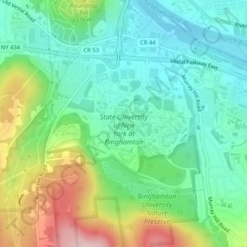
Name: State University of New York at Binghamton topographic map, elevation, terrain.
Average elevation: 1,050 ft
Minimum elevation: 807 ft
Maximum elevation: 1,581 ft
Other topographic maps
Click on a map to view its topography, its elevation and its terrain.
Kopernik Observatory & Science Center
United States > New York > Broome County > Town of Vestal > Tracy Creek
Kopernik Observatory & Science Center, 698, Underwood Road, Tracy Creek, Town of Vestal, Broome County, New York, 13850, United States
Average elevation: 1,483 ft
Ross Corners
United States > New York > Broome County > Town of Vestal
Ross Corners, Town of Vestal, Broome County, New York, United States
Average elevation: 997 ft