
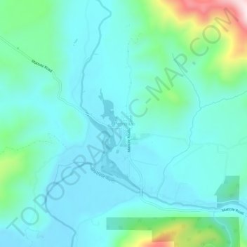
Petrolia topographic map
Interactive map
Click on the map to display elevation.
About this map
Name: Petrolia topographic map, elevation, terrain.
Average elevation: 328 ft
Minimum elevation: 36 ft
Maximum elevation: 1,627 ft
Other topographic maps
Click on a map to view its topography, its elevation and its terrain.
Eureka
United States > California > Humboldt County
Eureka, Humboldt County, California, United States
Average elevation: 59 ft
Arcata
United States > California > Humboldt County
Arcata, Humboldt County, California, 95521, United States
Average elevation: 269 ft
Kneeland
United States > California > Humboldt County
Kneeland, Humboldt County, California, United States
Average elevation: 1,545 ft
Loleta
United States > California > Humboldt County
Loleta, Humboldt County, California, United States
Average elevation: 115 ft
Humboldt Hill
United States > California > Humboldt County
Humboldt Hill, Humboldt County, California, United States
Average elevation: 148 ft
Maple Creek
United States > California > Humboldt County
Maple Creek, Humboldt County, California, 95550, United States
Average elevation: 906 ft
Whitethorn
United States > California > Humboldt County
Whitethorn, Humboldt County, California, United States
Average elevation: 1,263 ft
Holmes
United States > California > Humboldt County
Holmes, Humboldt County, California, 95569, United States
Average elevation: 374 ft
Redcrest
United States > California > Humboldt County
Redcrest, Humboldt County, California, 95569, United States
Average elevation: 636 ft
Bayside
United States > California > Humboldt County
Bayside, Humboldt County, California, 95524, United States
Average elevation: 171 ft
Briceland
United States > California > Humboldt County
Briceland, Humboldt County, California, United States
Average elevation: 906 ft
Fieldbrook
United States > California > Humboldt County
Fieldbrook, Humboldt County, California, United States
Average elevation: 420 ft
Weitchpec
United States > California > Humboldt County
Weitchpec, Humboldt County, California, United States
Average elevation: 1,161 ft
Samoa
United States > California > Humboldt County
Samoa, Humboldt County, California, 95564, United States
Average elevation: 3 ft
Englewood
United States > California > Humboldt County
Englewood, Humboldt County, California, 95569, United States
Average elevation: 581 ft
Glendale
United States > California > Humboldt County
Glendale, Humboldt County, California, 95525, United States
Average elevation: 246 ft
Fort Seward
United States > California > Humboldt County
Fort Seward, Humboldt County, California, United States
Average elevation: 653 ft
Notchko
United States > California > Humboldt County
Notchko, Humboldt County, California, United States
Average elevation: 951 ft
Rohnerville
United States > California > Humboldt County > Fortuna
Rohnerville, Fortuna, Humboldt County, California, 95540, United States
Average elevation: 203 ft
Bayview
United States > California > Humboldt County
Bayview, Humboldt County, California, United States
Average elevation: 39 ft
Cutten
United States > California > Humboldt County
Cutten, Humboldt County, California, United States
Average elevation: 144 ft
Fields Landing
United States > California > Humboldt County
Fields Landing, Humboldt County, California, 95537, United States
Average elevation: 95 ft
Hoopa
United States > California > Humboldt County
Hoopa, Humboldt County, California, United States
Average elevation: 810 ft
Hydesville
United States > California > Humboldt County
Hydesville, Humboldt County, California, 95547, United States
Average elevation: 531 ft
Indianola
United States > California > Humboldt County
Indianola, Humboldt County, California, 95524, United States
Average elevation: 167 ft
Manila
United States > California > Humboldt County
Manila, Humboldt County, California, United States
Average elevation: 3 ft
Pine Hills
United States > California > Humboldt County
Pine Hills, Humboldt County, California, United States
Average elevation: 236 ft
Alton
United States > California > Humboldt County
Alton, Humboldt County, California, 95540, United States
Average elevation: 167 ft
Carlotta
United States > California > Humboldt County
Carlotta, Humboldt County, California, 95547, United States
Average elevation: 276 ft
Johnsons
United States > California > Humboldt County
Johnsons, Humboldt County, California, United States
Average elevation: 961 ft
Pepperwood
United States > California > Humboldt County
Pepperwood, Humboldt County, California, 95569, United States
Average elevation: 492 ft
Riverside Park
United States > California > Humboldt County
Riverside Park, Humboldt County, California, United States
Average elevation: 522 ft
Blue Lake
United States > California > Humboldt County
Blue Lake, Humboldt County, California, United States
Average elevation: 243 ft
Fairhaven
United States > California > Humboldt County
Fairhaven, Humboldt County, California, 95564, United States
Average elevation: 10 ft
Phillipsville
United States > California > Humboldt County
Phillipsville, Humboldt County, California, 95559, United States
Average elevation: 853 ft
Westhaven-Moonstone
United States > California > Humboldt County
Westhaven-Moonstone, Humboldt County, California, United States
Average elevation: 407 ft
Blocksburg
United States > California > Humboldt County
Blocksburg, Humboldt County, California, United States
Average elevation: 1,726 ft
Bridgeville
United States > California > Humboldt County
Bridgeville, Humboldt County, California, United States
Average elevation: 1,322 ft
Dinsmore
United States > California > Humboldt County
Dinsmore, Humboldt County, California, United States
Average elevation: 2,913 ft
Elk River
United States > California > Humboldt County
Elk River, Pine Hills, Humboldt County, California, 95537, United States
Average elevation: 157 ft
Fernbridge
United States > California > Humboldt County
Fernbridge, Humboldt County, California, United States
Average elevation: 164 ft
Fruitland
United States > California > Humboldt County
Fruitland, Humboldt County, California, United States
Average elevation: 981 ft
Korbel
United States > California > Humboldt County
Korbel, Humboldt County, California, 95525, United States
Average elevation: 492 ft
Shively
United States > California > Humboldt County
Shively, Humboldt County, California, 95569, United States
Average elevation: 358 ft
South Fork Elk River
United States > California > Humboldt County > Pine Hills
South Fork Elk River, Pine Hills, Humboldt County, California, United States
Average elevation: 230 ft
Stafford
United States > California > Humboldt County
Stafford, Humboldt County, California, 95565, United States
Average elevation: 604 ft
McKinleyville
United States > California > Humboldt County
McKinleyville, Humboldt County, California, 95519, United States
Average elevation: 157 ft
Bucksport
United States > California > Humboldt County > Eureka
Bucksport, Eureka, Humboldt County, California, 95564, United States
Average elevation: 26 ft
McKinleyville
United States > California > Humboldt County
McKinleyville, Humboldt County, California, 95519, United States
Average elevation: 161 ft
Myrtletown
United States > California > Humboldt County
Myrtletown, Humboldt County, California, United States
Average elevation: 69 ft