
John Boyd Thacher State Park topographic map
Interactive map
Click on the map to display elevation.
About this map
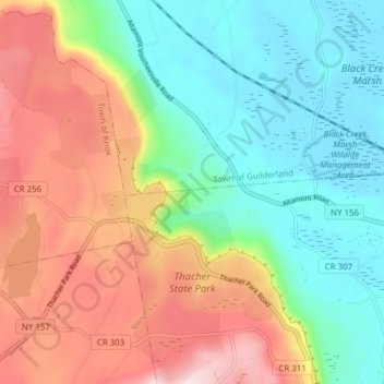
Name: John Boyd Thacher State Park topographic map, elevation, terrain.
Average elevation: 860 ft
Minimum elevation: 312 ft
Maximum elevation: 1,703 ft
The escarpment features rocks of the Upper Silurian and Upper and Middle Ordovician ages resting below the Devonian rocks. At the base of the escarpment, the Schenectady beds are visible. The Rondout "waterlime" or dolomite overlies the Schenectady beds and is most pronounced below Minelot Falls. The escarpment consists primarily of the Manlius Formation at the base, which is overlain by the Coeymans Formation. The Manlius Formation contains stromatoporoids and abundant desiccation features, notably prism cracks. The Coeymans Formation is a more massive limestone, appears bluish in color, and contains corals and brachiopods, notably gypidula coeymansensis. The gradational contact between the Manlius and Coeymans Formations represents a transgression, or rise in sea level. Overlying the Coeymans Formation, at the top of the escarpment, the Kalkberg Formation contains brachiopods and crinoids and is interpreted as even deeper marine deposits. The New Scotland Formation contains interbedded shale and sandstone; an exposure is found in Minelot Creek, up creek of the Paint Mine parking area. The Becraft Formation overlies the New Scotland Formation and is a coarse-grained limestone with abundant crinoid debris; it is best exposed in the northern section of the park near Carrick Road, where an unconformity separates the Becraft and overlying Oriskany Sandstone. Due to its predominant limestone bedrock, the park features karst topography which includes numerous disappearing streams, caves, sinkholes, and grikes. The park contains about 40 caves. The longest documented cave is Hailes Cave. This cave has 3,700 feet of mapped passages with about 2 miles of potentially unmapped passages. The park also contains glacial features, common to this region, in the form of striated bedrock and glacial erratics.
Other topographic maps
Click on a map to view its topography, its elevation and its terrain.
Wolf Hill
United States > New York > Albany County > Town of New Scotland
Wolf Hill, Town of New Scotland, Albany County, New York, 12041, United States
Average elevation: 1,263 ft
Unionville
United States > New York > Albany County > Town of New Scotland
Unionville, Town of New Scotland, Albany County, New York, 12067, United States
Average elevation: 289 ft
Clarksville
United States > New York > Albany County > Town of New Scotland
Clarksville, Town of New Scotland, Albany County, New York, 12041, United States
Average elevation: 797 ft
Tarrytown
United States > New York > Albany County > Town of New Scotland
Tarrytown, Town of New Scotland, Albany County, New York, 12041, United States
Average elevation: 728 ft
New Salem
United States > New York > Albany County > Town of New Scotland
New Salem, Town of New Scotland, Albany County, New York, 12186, United States
Average elevation: 696 ft
Feura Bush
United States > New York > Albany County > Town of New Scotland
Feura Bush, Town of New Scotland, Albany County, New York, 12607, United States
Average elevation: 312 ft
Village of Voorheesville
United States > New York > Albany County > Town of New Scotland
Village of Voorheesville, Town of New Scotland, Albany County, New York, 12186, United States
Average elevation: 351 ft