
Claremont topographic map
Interactive map
Click on the map to display elevation.
About this map
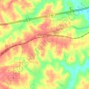
Name: Claremont topographic map, elevation, terrain.
Location: Claremont, Catawba County, North Carolina, United States (35.68416 -81.18128 35.73391 -81.12818)
Average elevation: 915 ft
Minimum elevation: 781 ft
Maximum elevation: 1,014 ft
Other topographic maps
Click on a map to view its topography, its elevation and its terrain.
Lake Norman of Catawba
United States > North Carolina > Catawba County > Lake Norman of Catawba
Lake Norman of Catawba, Catawba County, North Carolina, United States
Average elevation: 820 ft
Terrell
United States > North Carolina > Catawba County > Sherrills Ford
Terrell, Sherrills Ford, Catawba County, North Carolina, 28682, United States
Average elevation: 810 ft
Catawba
United States > North Carolina > Catawba County
Catawba, Catawba County, North Carolina, United States
Average elevation: 873 ft
Long View
United States > North Carolina > Catawba County
Long View, Catawba County, North Carolina, United States
Average elevation: 1,076 ft
Newton
United States > North Carolina > Catawba County
Newton, Catawba County, North Carolina, 28658, United States
Average elevation: 942 ft
Conover
United States > North Carolina > Catawba County
Conover, Catawba County, North Carolina, 28613, United States
Average elevation: 974 ft
Sherrills Ford
United States > North Carolina > Catawba County
Sherrills Ford, Catawba County, North Carolina, United States
Average elevation: 837 ft
Maiden
United States > North Carolina > Catawba County
Maiden, Catawba County, North Carolina, United States
Average elevation: 896 ft
Hickory
United States > North Carolina > Catawba County > Hickory
Hickory, Catawba County, North Carolina, 28602, United States
Average elevation: 1,070 ft
Mountain View
United States > North Carolina > Catawba County
Mountain View, Catawba County, North Carolina, 28602, United States
Average elevation: 1,020 ft
Banoak
United States > North Carolina > Catawba County > Banoak
Banoak, Catawba County, North Carolina, 28168, United States
Average elevation: 1,102 ft
Hickory
United States > North Carolina > Catawba County
Hickory, Catawba County, North Carolina, United States
Average elevation: 1,040 ft