
Noyes Park Creek topographic map
Interactive map
Click on the map to display elevation.
About this map
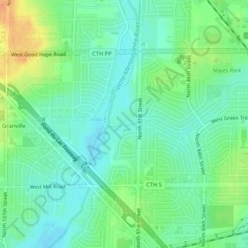
Name: Noyes Park Creek topographic map, elevation, terrain.
Average elevation: 745 ft
Minimum elevation: 702 ft
Maximum elevation: 820 ft
Other topographic maps
Click on a map to view its topography, its elevation and its terrain.
Lakeshore State Park
United States > Wisconsin > Milwaukee County > Milwaukee
Lakeshore State Park, Historic Third Ward, Milwaukee, Milwaukee County, Wisconsin, United States
Average elevation: 591 ft
Milwaukee
United States > Wisconsin > Milwaukee County > Milwaukee
Milwaukee, Milwaukee County, Wisconsin, 53233-2620, United States
Average elevation: 679 ft