
Stockbridge topographic map
Interactive map
Click on the map to display elevation.
About this map
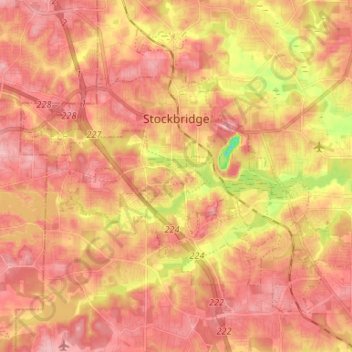
Name: Stockbridge topographic map, elevation, terrain.
Location: Stockbridge, Henry County, Georgia, United States (33.47925 -84.29218 33.57271 -84.15969)
Average elevation: 797 ft
Minimum elevation: 525 ft
Maximum elevation: 928 ft
Other topographic maps
Click on a map to view its topography, its elevation and its terrain.
Flippen
United States > Georgia > Henry County
Flippen, Henry County, Georgia, 30253, United States
Average elevation: 827 ft
Peeksville
United States > Georgia > Henry County
Peeksville, Henry County, Georgia, United States
Average elevation: 646 ft
Blacksville
United States > Georgia > Henry County
Blacksville, Henry County, Georgia, United States
Average elevation: 863 ft
Whitehouse
United States > Georgia > Henry County
Whitehouse, Henry County, Georgia, United States
Average elevation: 755 ft
Ola
United States > Georgia > Henry County
Ola, Henry County, Georgia, United States
Average elevation: 755 ft
McDonough
United States > Georgia > Henry County
McDonough, Henry County, Georgia, 30253, United States
Average elevation: 817 ft
Hiram Cook Lake
United States > Georgia > Henry County
Hiram Cook Lake, Henry County, Georgia, United States
Average elevation: 814 ft
Weems Lake
United States > Georgia > Henry County
Weems Lake, Henry County, Georgia, United States
Average elevation: 804 ft
Hampton
United States > Georgia > Henry County
Hampton, Henry County, Georgia, United States
Average elevation: 846 ft
Locust Grove
United States > Georgia > Henry County
Locust Grove, Henry County, Georgia, 30248, United States
Average elevation: 755 ft
McDonough
United States > Georgia > Henry County > McDonough
McDonough, Henry County, Georgia, 30253, United States
Average elevation: 814 ft
Kelleytown
United States > Georgia > Henry County
Kelleytown, Henry County, Georgia, United States
Average elevation: 722 ft