
Canaan Valley Resort State Park topographic map
Interactive map
Click on the map to display elevation.
About this map
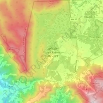
Name: Canaan Valley Resort State Park topographic map, elevation, terrain.
Average elevation: 3,389 ft
Minimum elevation: 2,352 ft
Maximum elevation: 4,432 ft
Other topographic maps
Click on a map to view its topography, its elevation and its terrain.
Otter Creek
United States > West Virginia > Tucker County
Otter Creek, Tucker County, West Virginia, United States
Average elevation: 2,999 ft
Dolly Sods Wilderness
United States > West Virginia > Tucker County
Dolly Sods Wilderness, Tucker County, West Virginia, United States
Average elevation: 3,419 ft
Davis
United States > West Virginia > Tucker County
Davis, Tucker County, West Virginia, United States
Average elevation: 3,133 ft
Thomas
United States > West Virginia > Tucker County > Thomas
Thomas, Tucker County, West Virginia, 26292, United States
Average elevation: 3,107 ft
Fairfax Stone State Park
United States > West Virginia > Tucker County
Fairfax Stone State Park, Tucker County, West Virginia, United States
Average elevation: 2,995 ft
Location
United States > West Virginia > Tucker County
Location, Tucker County, West Virginia, United States
Average elevation: 2,369 ft