
Aldie topographic map
Interactive map
Click on the map to display elevation.
About this map
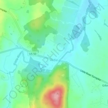
Name: Aldie topographic map, elevation, terrain.
Location: Aldie, Loudoun County, Virginia, United States (38.97292 -77.65078 38.98103 -77.63838)
Average elevation: 390 ft
Minimum elevation: 289 ft
Maximum elevation: 699 ft
Other topographic maps
Click on a map to view its topography, its elevation and its terrain.
Ashburn
United States > Virginia > Loudoun County
Ashburn, Loudoun County, Virginia, United States
Average elevation: 279 ft
Lansdowne
United States > Virginia > Loudoun County
Lansdowne, Loudoun County, Virginia, United States
Average elevation: 282 ft
Brambleton
United States > Virginia > Loudoun County
Brambleton, Loudoun County, Virginia, United States
Average elevation: 325 ft
South Riding
United States > Virginia > Loudoun County
South Riding, Loudoun County, Virginia, 20152, United States
Average elevation: 318 ft
Sugarland Run
United States > Virginia > Loudoun County
Sugarland Run, Loudoun County, Virginia, 20165, United States
Average elevation: 272 ft
Lowes Island
United States > Virginia > Loudoun County
Lowes Island, Loudoun County, Virginia, 20165, United States
Average elevation: 390 ft
Stone Ridge
United States > Virginia > Loudoun County > Stone Ridge
Stone Ridge, Loudoun County, Virginia, United States
Average elevation: 341 ft
Broad Run
United States > Virginia > Loudoun County > Ashburn
Broad Run, Ashburn, Loudoun County, Virginia, United States
Average elevation: 292 ft
Britain
United States > Virginia > Loudoun County
Britain, Loudoun County, Virginia, United States
Average elevation: 705 ft
Purcellville
United States > Virginia > Loudoun County
Purcellville, Loudoun County, Virginia, 20132, United States
Average elevation: 515 ft
Broadlands
United States > Virginia > Loudoun County
Broadlands, Loudoun County, Virginia, United States
Average elevation: 338 ft
Lucketts
United States > Virginia > Loudoun County
Lucketts, Loudoun County, Virginia, United States
Average elevation: 344 ft
Watson
United States > Virginia > Loudoun County
Watson, Loudoun County, Virginia, United States
Average elevation: 371 ft
North Fork
United States > Virginia > Loudoun County
North Fork, Loudoun County, Virginia, 20131, United States
Average elevation: 404 ft
Washington & Old Dominion Trail Regional Park
United States > Virginia > Loudoun County > Purcellville
Washington & Old Dominion Trail Regional Park, Historic Downtown Purcellville, Purcellville, Loudoun County, Virginia, United States
Average elevation: 531 ft
Woodburn
United States > Virginia > Loudoun County
Woodburn, Loudoun County, Virginia, 20178, United States
Average elevation: 531 ft
Bluemont
United States > Virginia > Loudoun County > Bluemont
Bluemont, Loudoun County, Virginia, 20135, United States
Average elevation: 928 ft
Arcola
United States > Virginia > Loudoun County
Arcola, Loudoun County, Virginia, 20107, United States
Average elevation: 305 ft
Leesburg
United States > Virginia > Loudoun County
Leesburg, Loudoun County, Virginia, United States
Average elevation: 371 ft
Dulles Town Center
United States > Virginia > Loudoun County > Dulles Town Center
Dulles Town Center, Loudoun County, Virginia, United States
Average elevation: 285 ft
Brambleton
United States > Virginia > Loudoun County
Brambleton, Loudoun County, Virginia, 20107, United States
Average elevation: 328 ft
South Riding
United States > Virginia > Loudoun County
South Riding, Loudoun County, Virginia, 20152, United States
Average elevation: 305 ft
Sterling
United States > Virginia > Loudoun County
Sterling, Loudoun County, Virginia, 20164, United States
Average elevation: 318 ft
Trapp
United States > Virginia > Loudoun County
Trapp, Loudoun County, Virginia, 20135, United States
Average elevation: 938 ft
Oatlands
United States > Virginia > Loudoun County
Oatlands, Loudoun County, Virginia, 20178, United States
Average elevation: 367 ft
Hillsboro
United States > Virginia > Loudoun County
Hillsboro, Loudoun County, Virginia, United States
Average elevation: 663 ft
Lovettsville
United States > Virginia > Loudoun County
Lovettsville, Loudoun County, Virginia, United States
Average elevation: 476 ft
Blue Ridge
United States > Virginia > Loudoun County
Blue Ridge, Loudoun County, Virginia, 20135, United States
Average elevation: 600 ft
Loudoun Valley Estates
United States > Virginia > Loudoun County
Loudoun Valley Estates, Loudoun County, Virginia, United States
Average elevation: 292 ft
Waterford
United States > Virginia > Loudoun County
Waterford, Loudoun County, Virginia, 20197, United States
Average elevation: 449 ft
Stone Ridge
United States > Virginia > Loudoun County > Stone Ridge
Stone Ridge, Loudoun County, Virginia, 20105, United States
Average elevation: 338 ft
Round Hill
United States > Virginia > Loudoun County
Round Hill, Loudoun County, Virginia, United States
Average elevation: 581 ft
Middleburg
United States > Virginia > Loudoun County
Middleburg, Loudoun County, Virginia, 20117, United States
Average elevation: 469 ft
Purcellville
United States > Virginia > Loudoun County
Purcellville, Loudoun County, Virginia, United States
Average elevation: 528 ft
Cascades
United States > Virginia > Loudoun County
Cascades, Loudoun County, Virginia, 20165, United States
Average elevation: 266 ft