
Make a donation
Gear up for your next adventure:
As an Amazon Associate, this site earns from qualifying purchases at no extra cost to you.
Youngsville topographic map
Click on the map to display elevation.
Make a donation
Gear up for your next adventure:
As an Amazon Associate, this site earns from qualifying purchases at no extra cost to you.
About this map
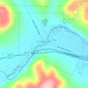
Name: Youngsville topographic map, elevation, terrain.
Location: Youngsville, Warren County, Pennsylvania, United States (41.84189 -79.32904 41.86110 -79.30248)
Average elevation: 1,339 ft
Minimum elevation: 1,181 ft
Maximum elevation: 1,808 ft
Warren County trails, hiking, mountain biking, running and outdoor activities
Make a donation
Gear up for your next adventure:
As an Amazon Associate, this site earns from qualifying purchases at no extra cost to you.
Other topographic maps
Click on a map to view its topography, its elevation and its terrain.
York Mountain
United States > Pennsylvania > Warren County > Brokenstraw Township
Average elevation: 1,640 ft
Make a donation
Gear up for your next adventure:
As an Amazon Associate, this site earns from qualifying purchases at no extra cost to you.