
Make a donation
Gear up for your next adventure:
As an Amazon Associate, this site earns from qualifying purchases at no extra cost to you.
Codegua topographic map
Click on the map to display elevation.
Make a donation
Gear up for your next adventure:
As an Amazon Associate, this site earns from qualifying purchases at no extra cost to you.
About this map
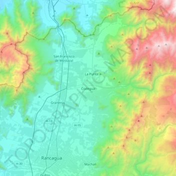
Name: Codegua topographic map, elevation, terrain.
Average elevation: 3,166 ft
Minimum elevation: 1,171 ft
Maximum elevation: 9,501 ft
Make a donation
Gear up for your next adventure:
As an Amazon Associate, this site earns from qualifying purchases at no extra cost to you.
Other topographic maps
Click on a map to view its topography, its elevation and its terrain.
Rancagua
Chile > Región del Libertador General Bernardo O'Higgins > Provincia de Cachapoal > Rancagua
La Cordillera de Los Andes alcanza en esta cuenca su mayor altitud, entre el Aconcagua y el Pico del Barroso, donde las cumbres sobrepasan los 5.500 m s. n. m..
Average elevation: 2,280 ft
Los Huertos
Chile > Región del Libertador General Bernardo O'Higgins > Provincia de Cachapoal > Rancagua
Average elevation: 1,490 ft
Río Tinguiririca
Chile > Región del Libertador General Bernardo O'Higgins > Provincia de Cachapoal > Pichidegua > San José de Marchigüe
Average elevation: 413 ft