
Kirtland topographic map
Interactive map
Click on the map to display elevation.
About this map
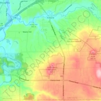
Name: Kirtland topographic map, elevation, terrain.
Location: Kirtland, Lake County, Ohio, United States (41.56974 -81.39209 41.64081 -81.29499)
Average elevation: 873 ft
Minimum elevation: 600 ft
Maximum elevation: 1,253 ft
Kirtland is located south of the lake shore plain of Lake Erie and is situated on the higher elevations of the Allegheny Plateau. The principal geographic features are the East Branch of the Chagrin River, Pierson's Knob,[18] and Gildersleeve Mountain, 1,163 feet (354 m) Daniel's Mountain,1,246 feet (380 m) is the high point.
Other topographic maps
Click on a map to view its topography, its elevation and its terrain.
Wickliffe
United States > Ohio > Lake County
Wickliffe, Lake County, Ohio, 44092, United States
Average elevation: 741 ft
Grand River
United States > Ohio > Lake County
Grand River, Lake County, Ohio, 44045, United States
Average elevation: 597 ft
Willowick
United States > Ohio > Lake County
Willowick, Lake County, Ohio, United States
Average elevation: 617 ft
Painesville
United States > Ohio > Lake County
Painesville, Lake County, Ohio, United States
Average elevation: 656 ft
Mentor
United States > Ohio > Lake County
Mentor, Lake County, Ohio, 44060, United States
Average elevation: 650 ft
Eastlake
United States > Ohio > Lake County
Eastlake, Lake County, Ohio, 44095, United States
Average elevation: 607 ft
South Madison
United States > Ohio > Lake County
South Madison, Lake County, Ohio, United States
Average elevation: 919 ft
Kirtland Hills
United States > Ohio > Lake County
Kirtland Hills, Lake County, Ohio, United States
Average elevation: 886 ft
Painesville
United States > Ohio > Lake County > Painesville > Painesville
Painesville, Lake County, Ohio, 44077, United States
Average elevation: 666 ft
Willoughby
United States > Ohio > Lake County
Willoughby, Lake County, Ohio, 44094, United States
Average elevation: 653 ft
Mentor
United States > Ohio > Lake County > Mentor > Mentor
Mentor, Lake County, Ohio, 44060, United States
Average elevation: 794 ft
Waite Hill
United States > Ohio > Lake County > Waite Hill
Waite Hill, Lake County, Ohio, 44094, United States
Average elevation: 738 ft
Willoughby Hills
United States > Ohio > Lake County
Willoughby Hills, Lake County, Ohio, United States
Average elevation: 791 ft
Gildersleeve Mountain
United States > Ohio > Lake County > Kirtland
Gildersleeve Mountain, Kirtland, Lake County, Ohio, United States
Average elevation: 991 ft