
Virginia topographic map
Interactive map
Click on the map to display elevation.
Virginia
Virginia's topography is characterized by a diverse landscape that transitions from the Atlantic Coastal Plain in the east to the mountainous regions in the west. The Coastal Plain features flat, low-lying areas that gradually rise to the Piedmont, known for its rolling hills and valleys. Further west, the Blue Ridge Mountains present sharp elevations, with the highest peak, Mount Rogers, reaching 5,729 feet. The Appalachian Ridge and Valley region showcases a series of valleys flanked by mountains, while the Appalachian Plateau in the southwest features rugged terrain interspersed with rivers and forests.
About this map
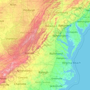
Name: Virginia topographic map, elevation, terrain.
Location: Virginia, United States (36.54079 -83.67537 39.46601 -75.16644)
Average elevation: 814 ft
Minimum elevation: -10 ft
Maximum elevation: 6,253 ft
United States trails, hiking, mountain biking, running and outdoor activities
Other topographic maps
Click on a map to view its topography, its elevation and its terrain.
Central Park
United States > New York > New York County > New York
In June 1856, Fernando Wood appointed a "consulting board" of seven people, headed by author Washington Irving, to inspire public confidence in the proposed development. Wood hired military engineer Egbert Ludovicus Viele as the park's chief engineer, tasking him with a topographical survey of the site. The…
Average elevation: 85 ft
Virginia Beach
United States > Virginia > Virginia Beach
According to the United States Census Bureau, the city has a total area of 497 square miles (1,290 km2), of which 249 square miles (640 km2) is land and 248 square miles (640 km2) (49.9%) is water. It is the largest city in Virginia by total area and third-largest city land area. The average elevation is 12…
Average elevation: 7 ft
Mount Washington
United States > New Hampshire > Coos County
Mount Washington, also known as Agiocochook, is an ultra-prominent mountain in the state of New Hampshire. It is the highest peak in the Northeastern United States at 6,288.2 ft (1,916.6 m) and the most topographically prominent mountain east of the Mississippi River.
Average elevation: 5,144 ft
San Francisco Bay Area
United States > California > San Francisco
The San Francisco Bay Area is characterized by a diverse and dynamic topography shaped by geological processes over millions of years. This region features a combination of coastal plains, steep hills, and rugged mountains, all influenced by the tectonic activity associated with the nearby San Andreas Fault…
Average elevation: 371 ft
Port Charlotte
United States > Florida > Charlotte County > Port Charlotte
Port Charlotte is characterized by a predominantly flat and low-lying terrain, typical of Florida’s coastal landscape. The area features a network of waterways, including the Peace River and Charlotte Harbor, which provide ample opportunities for recreational activities like boating and fishing. Elevations…
Average elevation: 13 ft
Appalachian Mountains
United States > North Carolina > Yancey County
The Appalachian Mountains (French: Appalaches), often called the Appalachians, are a system of mountains in eastern to northeastern North America. The Appalachians first formed roughly 480 million years ago during the Ordovician Period. They once reached elevations similar to those of the Alps and the Rocky…
Average elevation: 4,800 ft
Navarre
United States > Florida > Santa Rosa County
Navarre is located at 30°24′04″N 86°51′47″W / 30.401°N 86.863°W / 30.401; -86.863Coordinates: 30°24′04″N 86°51′47″W / 30.401°N 86.863°W / 30.401; -86.863. It is located within a portion of the Florida Panhandle observing the Central Time Zone. Elevation is at an average of 10 feet (3.0 m).
Average elevation: 13 ft
Anna Maria island
United States > Florida > Manatee County
Anna Maria Island features a flat, sandy topography typical of a barrier island on the Gulf Coast. With an average elevation of around 15 feet above sea level, the terrain includes broad beaches, low dunes, and narrow stretches of sandy soil, making it highly vulnerable to storm surges and tidal flooding. The…
Average elevation: 7 ft
El Dorado Hills
United States > California > El Dorado County > Cameron Park
El Dorado Hills (EDH), as defined by the 2010 census-designated place (CDP), is at the western border of El Dorado County, between the City of Folsom and the unincorporated community of Cameron Park. The northern limits of the CDP are Folsom Lake and the South Fork of the American River, where river rafters…
Average elevation: 833 ft
Mount Arvon
United States > Michigan > Baraga County > L'Anse Township
Mount Arvon (/ɑːrvɒn/ ARR-vahn) at 1,979 feet (603 m), is the highest natural point in the U.S. state of Michigan. Located in L'Anse Township, Baraga County, Mount Arvon is part of the Huron Mountains. It rises about eight miles (13 km) south of Lake Superior (elevation 591 feet [180 m]). On the list of…
Average elevation: 1,726 ft
Estes Park
United States > Colorado > Larimer County
Estes Park sits at an elevation of 7,522 feet (2,293 m) on the front range of the Rocky Mountains at the eastern entrance of the Rocky Mountain National Park. Its north, south and east extremities border the Roosevelt National Forest. Lumpy Ridge lies immediately north of Estes Park.
Average elevation: 8,343 ft
Baltimore
United States > Maryland > Baltimore
Baltimore is in north-central Maryland on the Patapsco River close to where it empties into the Chesapeake Bay. The city is also located on the fall line between the Piedmont Plateau and the Atlantic coastal plain, which divides Baltimore into "lower city" and "upper city". The city's elevation ranges from sea…
Average elevation: 213 ft
Evergreen
United States > Colorado > Jefferson County
Evergreen sits at an elevation of 7,220 feet (2,200 m) in the Rocky Mountains, 19 miles west of Denver, Colorado. Its addresses are oriented according to the Street_system_of_Denver.
Average elevation: 7,575 ft
East Texas
United States > Pennsylvania > Lehigh County > Lower Macungie Township
Average elevation: 413 ft
Blackboys
United States > Connecticut > Southeastern Connecticut Planning Region > East Lyme
Average elevation: 125 ft
Mount Stuart
United States > Washington > Chelan County
Mount Stuart is more notable for its local relief than for its absolute elevation. For example, the south face rises 5,000 feet (1,500 m) in just 2 horizontal miles (3.2 km). The northeast and northwest sides of the mountain exhibit similar steep relief. Due to its location away from higher peaks, Mount Stuart…
Average elevation: 6,919 ft
Florida Keys
United States > Florida > Monroe County
Tropical cyclones present special dangers and challenges to the entire Keys. Because no area of the islands is more than 20 feet (6.1 m) above sea level (and many are only a few feet elevation), and water surrounds the islands, nearly every neighborhood is subject to flooding as well as hurricane winds. In…
Average elevation: 0 ft
Grand Lake
United States > Colorado > Grand County
Established in 1881, Grand Lake sits at an elevation of 8,369 feet (2,551 m) and derives its name from the lake on whose shores it is situated: Grand Lake, the largest natural body of water in Colorado. The town of Grand Lake was originally an outfitting and supply point for the mining settlements of Lulu…
Average elevation: 8,629 ft
Mount Rushmore
United States > South Dakota > Pennington County
Mount Rushmore National Memorial is centered on a colossal sculpture carved into the granite face of Mount Rushmore (Lakota: Tȟuŋkášila Šákpe, or Six Grandfathers) in the Black Hills near Keystone, South Dakota. Sculptor Gutzon Borglum created the sculpture's design and oversaw the project's execution…
Average elevation: 5,125 ft
Mauna Loa
United States > Hawaii > Hawaiʻi County
Mauna Loa is the largest subaerial and second largest overall volcano in the world (behind Tamu Massif), covering a land area of 5,271 km2 (2,035 sq mi) and spans a maximum width of 120 km (75 mi). Consisting of approximately 65,000 to 80,000 km3 (15,600 to 19,200 cu mi) of solid rock, it makes up more than…
Average elevation: 13,245 ft
South Sister
United States > Oregon > Deschutes County
The Three Sisters are closely spaced volcanic peaks in the U.S. state of Oregon. They are part of the Cascade Volcanic Arc, a segment of the Cascade Range in western North America extending from southern British Columbia through Washington and Oregon to Northern California. Each over 10,000 feet (3,000 meters)…
Average elevation: 8,642 ft
Naval Nuclear Power Training Command
United States > South Carolina > Berkeley County > Goose Creek
Average elevation: 16 ft
San Diego
United States > California > San Diego County > San Diego
The climate in San Diego, like most of Southern California, often varies significantly over short geographical distances, resulting in microclimates. In San Diego, this is mostly because of the city's topography (the Bay, and the numerous hills, mountains, and canyons). Frequently, particularly during the "May…
Average elevation: 187 ft
Palm Harbor
United States > Florida > Pinellas County
Palm Harbor is characterized by its unique topography, which features a relatively rare hilly landscape for the region. Unlike much of the surrounding areas in Pinellas County, which are predominantly flat, Palm Harbor includes elevations that can reach up to about 75 feet above sea level. This elevation gives…
Average elevation: 30 ft
Long Leaf Acres
United States > North Carolina > New Hanover County > Wilmington
Average elevation: 36 ft
Creekside Village
United States > California > Santa Clara County > Los Gatos
Average elevation: 545 ft
Nīnole
United States > Hawaii > Hawaiʻi County
One Nīnole is in the Kaʻū District south of Route 11 (Hawaii Belt Road) adjacent to the south of Punaluʻu Beach. It was on Nīnole Cove, a small bay at the shore of what is now Sea Mountain Golf Course. The village was the birthplace of Henry ʻŌpūkahaʻia (1792–1818) who inspired the missionary…
Average elevation: 322 ft
La Plata Peak
United States > Colorado > Chaffee County
The elevation of 14,361 feet marked on the USGS Mount Elbert Quadrangle is incorrect, and should read 14,336 feet (in the NGVD 29 vertical datum).
Average elevation: 12,730 ft
Club Manor East of Grand Hampton
United States > Florida > Hillsborough County > Tampa
Average elevation: 56 ft
Pocono Lake
United States > Pennsylvania > Monroe County > Tobyhanna Township
Average elevation: 1,781 ft
Scottsdale
United States > Arizona > Maricopa County > Scottsdale
The city is in the Salt River Valley, or the "Valley of the Sun," in the northern reaches of the Sonoran Desert. Scottsdale, 31 mi (50 km) long and 11.4 mi (18.3 km) wide at its widest point, shares boundaries with many other municipalities and entities. On the west, Scottsdale is bordered by Phoenix, Paradise…
Average elevation: 1,358 ft
Georgetown
United States > Texas > Georgetown
The city is located on the northeastern edge of Texas Hill Country. Portions of Georgetown are located on either side of the Balcones Escarpment, a fault line in which the areas roughly east of IH-35 are flat and characterized by having black, fertile soils of the Blackland Prairie, and the west side of the…
Average elevation: 719 ft