
Manchester topographic map
Interactive map
Click on the map to display elevation.
About this map
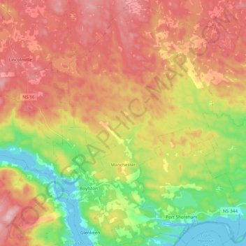
Name: Manchester topographic map, elevation, terrain.
Average elevation: 328 ft
Minimum elevation: -7 ft
Maximum elevation: 633 ft
Other topographic maps
Click on a map to view its topography, its elevation and its terrain.
Western Island
Canada > Nova Scotia > Guysborough District Municipality > Cole Harbour
Western Island, Cole Harbour, Guysborough District Municipality, Guysborough County, Nova Scotia, Canada
Average elevation: 85 ft
Cole Harbour
Canada > Nova Scotia > Guysborough District Municipality
Cole Harbour, Guysborough District Municipality, Guysborough County, Nova Scotia, Canada
Average elevation: 128 ft
Boylston
Canada > Nova Scotia > Guysborough District Municipality
Boylston, Guysborough District Municipality, Guysborough County, Nova Scotia, B0H 1G0, Canada
Average elevation: 249 ft