
Askøy topographic map
Interactive map
Click on the map to display elevation.
About this map
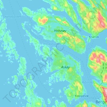
Name: Askøy topographic map, elevation, terrain.
Location: Askøy, Vestland, Norway (60.38177 4.89788 60.63189 5.28026)
Average elevation: 125 ft
Minimum elevation: -16 ft
Maximum elevation: 1,696 ft
Other topographic maps
Click on a map to view its topography, its elevation and its terrain.
Vinjane
Norway > Vestland > Aurlandsvangen
Vinjane, Aurlandsvangen, Aurland, Vestland, 5745, Norway
Average elevation: 758 ft
Strandebarm
Strandebarm, Kvam herad, Vestland, 5630, Norway
Average elevation: 594 ft