
Westlake Village topographic map
Interactive map
Click on the map to display elevation.
About this map
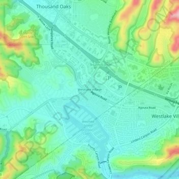
Name: Westlake Village topographic map, elevation, terrain.
Average elevation: 1,001 ft
Minimum elevation: 830 ft
Maximum elevation: 1,486 ft
Other topographic maps
Click on a map to view its topography, its elevation and its terrain.
Thousand Oaks
United States > California > Ventura County > Thousand Oaks
Thousand Oaks, Ventura County, California, United States
Average elevation: 994 ft
Newbury Park
United States > California > Ventura County > Thousand Oaks
Newbury Park, Thousand Oaks, Ventura County, CAL Fire Southern Region, California, 91320, United States
Average elevation: 860 ft
Thousand Oaks
United States > California > Ventura County > Thousand Oaks
Thousand Oaks, Ventura County, California, 91362, United States
Average elevation: 945 ft
Greenwich Village
United States > California > Ventura County > Thousand Oaks
Greenwich Village, Thousand Oaks, Ventura County, CAL Fire Southern Region, California, 91360, United States
Average elevation: 902 ft
Ventu Park
United States > California > Ventura County > Thousand Oaks > Newbury Park
Ventu Park, Newbury Park, Thousand Oaks, Ventura County, CAL Fire Southern Region, California, 91320, United States
Average elevation: 820 ft