
Lufkin topographic map
Interactive map
Click on the map to display elevation.
About this map
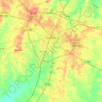
Name: Lufkin topographic map, elevation, terrain.
Location: Lufkin, Angelina County, Texas, United States (31.25458 -94.77505 31.38796 -94.65809)
Average elevation: 289 ft
Minimum elevation: 167 ft
Maximum elevation: 420 ft
The elevation of Lufkin is 139 to 404 ft above mean sea level.
Other topographic maps
Click on a map to view its topography, its elevation and its terrain.
Shawnee
United States > Texas > Angelina County
Shawnee, Angelina County, Texas, United States
Average elevation: 246 ft
Zavalla
United States > Texas > Angelina County
Zavalla, Angelina County, Texas, United States
Average elevation: 249 ft
Burke
United States > Texas > Angelina County > Burke
Burke, Angelina County, Texas, United States
Average elevation: 253 ft
Pollok
United States > Texas > Angelina County
Pollok, Angelina County, Texas, 75969, United States
Average elevation: 299 ft
Diboll
United States > Texas > Angelina County
Diboll, Angelina County, Texas, 75941, United States
Average elevation: 220 ft
Diboll
United States > Texas > Angelina County > Diboll > Diboll
Diboll, Angelina County, Texas, 75941, United States
Average elevation: 207 ft