
Chickamauga topographic map
Interactive map
Click on the map to display elevation.
About this map
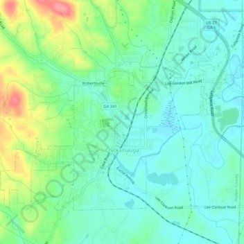
Name: Chickamauga topographic map, elevation, terrain.
Location: Chickamauga, Walker County, Georgia, United States (34.86056 -85.31627 34.89152 -85.26424)
Average elevation: 781 ft
Minimum elevation: 696 ft
Maximum elevation: 994 ft
Other topographic maps
Click on a map to view its topography, its elevation and its terrain.
Marsh Crossing
United States > Georgia > Walker County
Marsh Crossing, Walker County, Georgia, United States
Average elevation: 1,024 ft
Yates Lake
United States > Georgia > Walker County
Yates Lake, Walker County, Georgia, United States
Average elevation: 1,168 ft
Fairview
United States > Georgia > Walker County
Fairview, Walker County, Georgia, United States
Average elevation: 863 ft
Lookout Mountain
United States > Georgia > Walker County
Lookout Mountain, Walker County, Georgia, 30750, United States
Average elevation: 1,332 ft
Chattanooga Valley
United States > Georgia > Walker County
Chattanooga Valley, Walker County, Georgia, 30725, United States
Average elevation: 906 ft
Rock Spring
United States > Georgia > Walker County
Rock Spring, Walker County, Georgia, 30739, United States
Average elevation: 853 ft
Cenchat
United States > Georgia > Walker County
Cenchat, Walker County, Georgia, 30725, United States
Average elevation: 843 ft
Rossville
United States > Georgia > Walker County
Rossville, Walker County, Georgia, United States
Average elevation: 771 ft
White Oak
United States > Georgia > Walker County > White Oak
White Oak, Walker County, Georgia, 30741, United States
Average elevation: 817 ft
LaFayette
United States > Georgia > Walker County
LaFayette, Walker County, Georgia, United States
Average elevation: 906 ft