
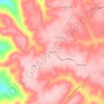
Crawford topographic map
Interactive map
Click on the map to display elevation.
About this map
Name: Crawford topographic map, elevation, terrain.
Average elevation: 1,719 ft
Minimum elevation: 1,040 ft
Maximum elevation: 1,900 ft
Other topographic maps
Click on a map to view its topography, its elevation and its terrain.
Alpine
United States > Tennessee > Overton County
Alpine, Overton County, Middle Tennessee, Tennessee, United States
Average elevation: 1,020 ft
Muddy Pond
United States > Tennessee > Overton County
Muddy Pond, Overton County, Tennessee, United States
Average elevation: 1,706 ft
Okalona
United States > Tennessee > Overton County
Okalona, Overton County, Tennessee, United States
Average elevation: 1,024 ft
Ozone
United States > Tennessee > Overton County > Ozone
Ozone, Overton County, Tennessee, United States
Average elevation: 974 ft
Livingston
United States > Tennessee > Overton County
Livingston, Overton County, Middle Tennessee, Tennessee, 38570, United States
Average elevation: 1,145 ft
Hilham
United States > Tennessee > Overton County
Hilham, Overton County, Middle Tennessee, Tennessee, 38568, United States
Average elevation: 1,050 ft
Allred
United States > Tennessee > Overton County > Allred
Allred, Overton County, Tennessee, 38542, United States
Average elevation: 1,211 ft