
Adirondack Park topographic map
Interactive map
Click on the map to display elevation.
About this map
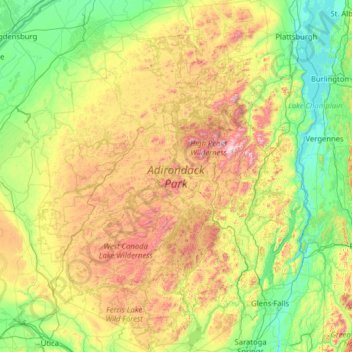
Name: Adirondack Park topographic map, elevation, terrain.
Location: Adirondack Park, New York, United States (43.05236 -75.31968 44.87791 -73.29338)
Average elevation: 1,217 ft
Minimum elevation: 82 ft
Maximum elevation: 4,944 ft
The surface of many of the lakes lies at an elevation above 1,500 ft (457 m); their shores are usually rocky and irregular, and the wild scenery within their vicinity has made them very attractive to tourists. It is the site of the Adirondack Canoe Classic. Flatwater and whitewater canoeing and kayaking are very popular. Hundreds of lakes, ponds, and slow-moving streams link to provide routes ranging from under one mile (1.6 km) to weeklong treks. Whitewater kayaking and canoeing are popular on many free-flowing rivers in the Adirondacks, particularly in the spring. Whitewater rafting trips are run in the spring on the Moose River near Old Forge. Raft trips are possible on the Hudson River near North River from April to October, due to dam releases provided by the Town of Indian Lake.
Other topographic maps
Click on a map to view its topography, its elevation and its terrain.
Manhattan
United States > New York > New York County > New York
Manhattan, New York County, New York, United States
Average elevation: 52 ft
City of Syracuse
United States > New York > Onondaga County
City of Syracuse, Onondaga County, New York, United States
Average elevation: 564 ft
The Bronx
United States > New York > New York
The Bronx, New York, United States
Average elevation: 75 ft
Dutchess County
Dutchess County, New York, United States
Average elevation: 587 ft
Buffalo
United States > New York > Erie County
Buffalo, Erie County, New York, United States
Average elevation: 607 ft
Brooklyn
United States > New York > New York
Brooklyn, Kings County, New York, United States
Average elevation: 30 ft
Monroe County
Monroe County, New York, United States
Average elevation: 400 ft
Central Park
United States > New York > New York County > New York
Central Park, New York County, New York, United States
Average elevation: 85 ft
City of Ithaca
United States > New York > Tompkins County
City of Ithaca, Tompkins County, New York, United States
Average elevation: 640 ft
Finger Lakes National Forest
United States > New York > Schuyler County > Town of Hector
Finger Lakes National Forest, Town of Hector, Schuyler County, New York, 14818, United States
Average elevation: 1,168 ft
Staten Island
United States > New York > New York
Staten Island, Richmond County, New York, United States
Average elevation: 30 ft
City of Binghamton
United States > New York > Broome County
City of Binghamton, Dickinson, Broome County, New York, 13905, United States
Average elevation: 1,053 ft
Upper West Side
United States > New York > New York
Upper West Side, Manhattan Community Board 7, Manhattan, New York County, New York, United States
Average elevation: 75 ft
Orange County
Orange County, New York, United States
Average elevation: 636 ft
Westchester County
Westchester County, New York, United States
Average elevation: 312 ft
Town of Sangerfield
United States > New York > Oneida County
Town of Sangerfield, Oneida County, New York, United States
Average elevation: 1,430 ft
Town of Shelter Island
United States > New York > Suffolk County
Town of Shelter Island, Suffolk County, New York, United States
Average elevation: 10 ft
East Hampton
United States > New York > Suffolk County > East Hampton > Village of East Hampton
East Hampton, Village of East Hampton, Suffolk County, New York, 11937, United States
Average elevation: 39 ft
Oneida County
Oneida County, New York, United States
Average elevation: 1,086 ft
Montauk
United States > New York > Suffolk County > Town of East Hampton
Montauk, Town of East Hampton, Suffolk County, New York, 11954, United States
Average elevation: 7 ft
City of Plattsburgh
United States > New York > Clinton County
City of Plattsburgh, Clinton County, New York, United States
Average elevation: 164 ft
Manhattan Island
United States > New York > New York
Manhattan Island, New York, United States
Average elevation: 56 ft
Putnam County
Putnam County, New York, United States
Average elevation: 554 ft
Godeffroy
United States > New York > Orange County
Godeffroy, Town of Deerpark, Orange County, New York, 12739, United States
Average elevation: 705 ft
City of Schenectady
United States > New York > Schenectady County
City of Schenectady, Schenectady County, New York, 12345, United States
Average elevation: 328 ft
City of Yonkers
United States > New York > Westchester County
City of Yonkers, Westchester County, New York, United States
Average elevation: 190 ft
Lake George
United States > New York > Warren County > Town of Bolton
Lake George, Town of Bolton, Warren County, New York, United States
Average elevation: 810 ft
Cortland County
Cortland County, New York, United States
Average elevation: 1,486 ft
Big Indian
United States > New York > Ulster County > Town of Shandaken
Big Indian, Town of Shandaken, Ulster County, New York, 12410, United States
Average elevation: 1,762 ft
Town of Clifton Park
United States > New York > Saratoga County
Town of Clifton Park, Saratoga County, New York, United States
Average elevation: 279 ft
Saratoga County
Saratoga County, New York, United States
Average elevation: 715 ft
Roosevelt Island
United States > New York > New York County > New York
Roosevelt Island, Manhattan, New York County, New York, 10044, United States
Average elevation: 43 ft
Ulster County
Ulster County, New York, United States
Average elevation: 1,125 ft
Graymoor
United States > New York > Putnam County
Graymoor, Town of Philipstown, Putnam County, New York, 10524, United States
Average elevation: 548 ft
City of Rye
United States > New York > Westchester County
City of Rye, Westchester County, New York, United States
Average elevation: 30 ft
Village of Scarsdale
United States > New York > Westchester County
Village of Scarsdale, Westchester County, New York, 10583, United States
Average elevation: 249 ft
Rensselaer County
Rensselaer County, New York, United States
Average elevation: 784 ft
Town of Vestal
United States > New York > Broome County
Town of Vestal, Broome County, New York, United States
Average elevation: 1,220 ft
Town of Catskill
United States > New York > Greene County
Town of Catskill, Greene County, New York, United States
Average elevation: 194 ft
City of Troy
United States > New York > Rensselaer County
City of Troy, Rensselaer County, New York, United States
Average elevation: 266 ft
Tug Hill
United States > New York > Oswego Town
Tug Hill, Oswego Town, Town of Oswego, Oswego County, New York, United States
Average elevation: 358 ft
Troy
United States > New York > Rensselaer County
Troy, Rensselaer County, New York, 12181, United States
Average elevation: 449 ft
Mill Pond Park
United States > New York > New York
Mill Pond Park, Bronx County, The Bronx, New York, United States
Average elevation: 59 ft
Tompkins County
Tompkins County, New York, United States
Average elevation: 1,237 ft
Saratoga Springs
United States > New York > Saratoga County > Saratoga Springs
Saratoga Springs, City of Saratoga Springs, Saratoga County, New York, 12866, United States
Average elevation: 528 ft