
Red Lodge topographic map
Interactive map
Click on the map to display elevation.
About this map
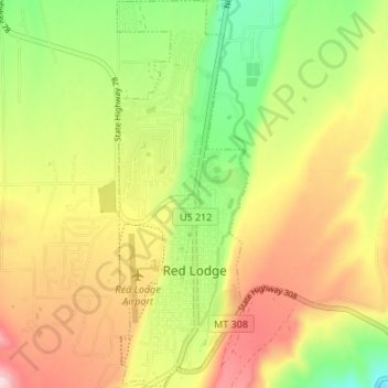
Name: Red Lodge topographic map, elevation, terrain.
Location: Red Lodge, Carbon County, Montana, 59068, United States (45.17150 -109.26051 45.21889 -109.23767)
Average elevation: 5,643 ft
Minimum elevation: 5,233 ft
Maximum elevation: 6,070 ft
Red Lodge experiences a continental climate (Köppen Dfb) with cold, somewhat dry winters and warm, wetter summers. Summers are cooler than in areas of Montana further north, due to the high elevation. Winters however, are milder than areas further to the east due to the chinook wind influence, as with most of Montana.
Other topographic maps
Click on a map to view its topography, its elevation and its terrain.
Boyd
United States > Montana > Carbon County
Boyd, Carbon County, Montana, 59013, United States
Average elevation: 4,065 ft
Luther
United States > Montana > Carbon County
Luther, Carbon County, Montana, United States
Average elevation: 5,262 ft
Joliet
United States > Montana > Carbon County
Joliet, Carbon County, Montana, 59041, United States
Average elevation: 3,812 ft
Bridger
United States > Montana > Carbon County
Bridger, Carbon County, Montana, 59014, United States
Average elevation: 3,707 ft