
Tuskegee topographic map
Interactive map
Click on the map to display elevation.
About this map
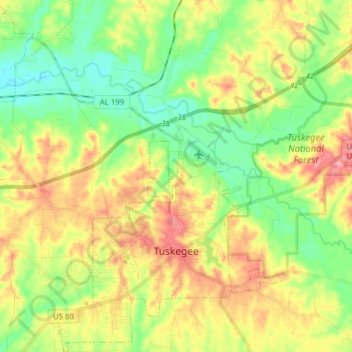
Name: Tuskegee topographic map, elevation, terrain.
Location: Tuskegee, Macon County, Alabama, United States (32.38655 -85.78703 32.51725 -85.64335)
Average elevation: 344 ft
Minimum elevation: 213 ft
Maximum elevation: 515 ft
Other topographic maps
Click on a map to view its topography, its elevation and its terrain.
Shorter
United States > Alabama > Macon County
Shorter, Macon County, Alabama, United States
Average elevation: 249 ft