
Mount Washington topographic map
Interactive map
Click on the map to display elevation.
About this map
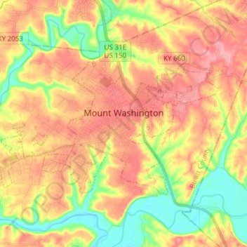
Name: Mount Washington topographic map, elevation, terrain.
Average elevation: 604 ft
Minimum elevation: 430 ft
Maximum elevation: 748 ft
Other topographic maps
Click on a map to view its topography, its elevation and its terrain.
Brooks
United States > Kentucky > Bullitt County
Brooks, Bullitt County, Kentucky, 40109, United States
Average elevation: 620 ft
Hillview
United States > Kentucky > Bullitt County
Hillview, Bullitt County, Kentucky, United States
Average elevation: 531 ft
Bernheim Forest
United States > Kentucky > Bullitt County
Bernheim Forest, Bullitt County, Kentucky, United States
Average elevation: 755 ft
Salt River
United States > Kentucky > Bullitt County > Shepherdsville
Salt River, Shepherdsville, Bullitt County, Kentucky, 40165, United States
Average elevation: 459 ft
Phelps Knob
United States > Kentucky > Bullitt County
Phelps Knob, Bullitt County, Kentucky, 40165, United States
Average elevation: 528 ft
Dawson Knob
United States > Kentucky > Bullitt County
Dawson Knob, Bullitt County, Kentucky, United States
Average elevation: 666 ft