
Marathon topographic map
Interactive map
Click on the map to display elevation.
About this map
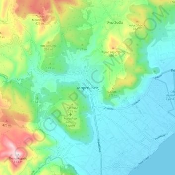
Name: Marathon topographic map, elevation, terrain.
Average elevation: 479 ft
Minimum elevation: -3 ft
Maximum elevation: 1,850 ft
World records were not officially recognized by the IAAF until 1 January 2004; previously, the best times for the marathon were referred to as the 'world best'. Courses must conform to IAAF standards for a record to be recognized. However, marathon routes still vary greatly in elevation, course, and surface, making exact comparisons impossible. Typically, the fastest times are set over relatively flat courses near sea level, during good weather conditions and with the assistance of pacesetters.
Other topographic maps
Click on a map to view its topography, its elevation and its terrain.
Αρχή
Greece > Attica > Regional Unit of East Attica
Αρχή, Regional Unit of East Attica, Attica, Greece
Average elevation: 49 ft
Gerakas Municipal Unit
Greece > Attica > Regional Unit of East Attica > Gerakas Municipal Unit
Gerakas Municipal Unit, Municipality of Pallini, Regional Unit of East Attica, Attica, 15344, Greece
Average elevation: 850 ft
Municipality of Dionysos
Greece > Attica > Regional Unit of East Attica
Municipality of Dionysos, Regional Unit of East Attica, Attica, Greece
Average elevation: 1,263 ft