
Tomohon topographic map
Interactive map
Click on the map to display elevation.
About this map
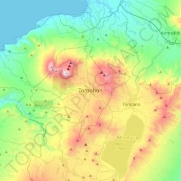
Name: Tomohon topographic map, elevation, terrain.
Location: Tomohon, North Sulawesi, 95442, Indonesia (1.16559 124.67861 1.48559 124.99861)
Average elevation: 1,654 ft
Minimum elevation: 0 ft
Maximum elevation: 5,121 ft
Other topographic maps
Click on a map to view its topography, its elevation and its terrain.
Kampung Jawa
Indonesia > North Sulawesi > Tomohon
Kampung Jawa, Tomohon, North Sulawesi, Sulawesi, 95439, Indonesia
Average elevation: 2,516 ft