
Warcino topographic map
Interactive map
Click on the map to display elevation.
About this map
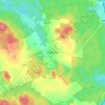
Name: Warcino topographic map, elevation, terrain.
Average elevation: 272 ft
Minimum elevation: 161 ft
Maximum elevation: 420 ft
Other topographic maps
Click on a map to view its topography, its elevation and its terrain.
Główczyce
Poland > Pomeranian Voivodeship > Słupsk County
Główczyce, gmina Główczyce, Słupsk County, Pomeranian Voivodeship, 76-220, Poland
Average elevation: 89 ft
Ustka
Poland > Pomeranian Voivodeship > Słupsk County > Ustka
Ustka, Słupsk County, Pomeranian Voivodeship, Poland
Average elevation: 20 ft
Kępice
Poland > Pomeranian Voivodeship > Słupsk County
Kępice, gmina Kępice, Słupsk County, Pomeranian Voivodeship, Poland
Average elevation: 220 ft
Kobylnica
Poland > Pomeranian Voivodeship > Słupsk County
Kobylnica, gmina Kobylnica, Słupsk County, Pomeranian Voivodeship, Poland
Average elevation: 148 ft
Barcino
Poland > Pomeranian Voivodeship > Słupsk County
Barcino, gmina Kępice, Słupsk County, Pomeranian Voivodeship, 77-232, Poland
Average elevation: 256 ft