
Desná topographic map
Interactive map
Click on the map to display elevation.
About this map
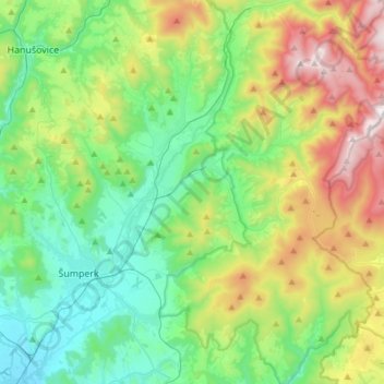
Name: Desná topographic map, elevation, terrain.
Average elevation: 2,005 ft
Minimum elevation: 925 ft
Maximum elevation: 4,534 ft
Other topographic maps
Click on a map to view its topography, its elevation and its terrain.
Tištín
Czech Republic > Central Moravia > Tištín
Tištín, okres Prostějov, Olomouc Region, Central Moravia, 79829, Czech Republic
Average elevation: 771 ft
017
Czech Republic > Central Moravia > Jeseník
017, Jeseník, okres Jeseník, Olomouc Region, Central Moravia, 79001, Czech Republic
Average elevation: 1,919 ft
Litenčice
Czech Republic > Central Moravia > Litenčice
Litenčice, okres Kroměříž, Zlínský kraj, Central Moravia, 76813, Czech Republic
Average elevation: 1,158 ft
Protivanov
Czech Republic > Central Moravia > Protivanov
Protivanov, okres Prostějov, Olomouc Region, Central Moravia, 79848, Czech Republic
Average elevation: 2,090 ft