
Uttarahalli topographic map
Interactive map
Click on the map to display elevation.
About this map
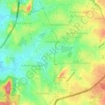
Name: Uttarahalli topographic map, elevation, terrain.
Average elevation: 2,864 ft
Minimum elevation: 2,717 ft
Maximum elevation: 3,061 ft
Other topographic maps
Click on a map to view its topography, its elevation and its terrain.
BTM
India > Karnataka > Bangalore South > Bengaluru
BTM, MICO Layout, BTM Layout Ward, South Zone, Bengaluru, Bangalore South, Bengaluru Urban District, Karnataka, India
Average elevation: 2,949 ft
Koramangala
India > Karnataka > Bangalore South > Bengaluru
Koramangala, South Zone, Bengaluru, Bangalore South, Bengaluru Urban District, Karnataka, 560034, India
Average elevation: 2,933 ft
Kasavanahalli Lake
India > Karnataka > Bangalore South > Bengaluru
Kasavanahalli Lake, Bellanduru, Mahadevapura Zone, Bengaluru, Bangalore South, Bangalore Urban, Karnataka, India
Average elevation: 2,936 ft