
Malampa topographic map
Interactive map
Click on the map to display elevation.
About this map
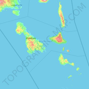
Name: Malampa topographic map, elevation, terrain.
Location: Malampa, Vanuatu (-16.97992 166.73228 -15.76333 168.73395)
Average elevation: 89 ft
Minimum elevation: 0 ft
Maximum elevation: 4,639 ft
Other topographic maps
Click on a map to view its topography, its elevation and its terrain.
TAFEA Provincial Disaster Committee
TAFEA Provincial Disaster Committee, Nakepau, Lénakel, Tafea, Vanuatu
Average elevation: 240 ft
Etas
Vanuatu > Shefa Province > Port Vila > Etas
Etas, Port Vila, Shefa Province, Vanuatu
Average elevation: 171 ft
Cook Reef
Vanuatu > Shefa Province > Port Vila
Cook Reef, Port Vila, Shefa Province, Vanuatu
Average elevation: 0 ft