
La Sierra topographic map
Interactive map
Click on the map to display elevation.
About this map
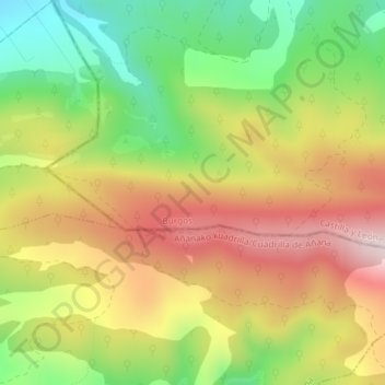
Name: La Sierra topographic map, elevation, terrain.
Average elevation: 2,592 ft
Minimum elevation: 1,893 ft
Maximum elevation: 3,304 ft
Other topographic maps
Click on a map to view its topography, its elevation and its terrain.
La Sierra
Spain > Castile and León > Condado de Treviño
La Sierra, Condado de Treviño, Burgos, Castile and León, Spain
Average elevation: 2,907 ft
Santa Cruz
Spain > Castile and León > Condado de Treviño
Santa Cruz, Condado de Treviño, Ebro, Burgos, Castile and León, Spain
Average elevation: 2,198 ft
San Juan
Spain > Castile and León > Condado de Treviño
San Juan, Condado de Treviño, Ebro, Burgos, Castile and León, Spain
Average elevation: 2,129 ft
Atua
Spain > Castile and León > Condado de Treviño
Atua, Condado de Treviño, Ebro, Burgos, Castile and León, Spain
Average elevation: 2,064 ft