
Jeju Island topographic map
Interactive map
Click on the map to display elevation.
About this map
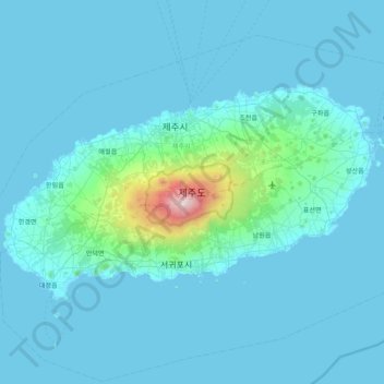
Name: Jeju Island topographic map, elevation, terrain.
Location: Jeju Island, Jeju, South Korea (33.19505 126.16064 33.56564 126.94701)
Average elevation: 322 ft
Minimum elevation: -3 ft
Maximum elevation: 6,309 ft
The climate of the highlands in the middle of the island where Hallasan is located is quite different from those of the rest of the island. The higher the altitude, the lower the average temperature and the colder the climate. The highlands of Jeju Island have the highest annual precipitation in Korea.
Other topographic maps
Click on a map to view its topography, its elevation and its terrain.
Austrailia Pavilion
Austrailia Pavilion, Makgye-dong, Gwacheon-si, Gyeonggi, South Korea
Average elevation: 472 ft
24228
24228, Chuncheon-si, Gangwon State, South Korea
Average elevation: 279 ft
16037
16037, Naeson 1-dong, Uiwang-si, Gyeonggi, South Korea
Average elevation: 322 ft
Yeongtong-gu
Yeongtong-gu, Suwon-si, Gyeonggi, South Korea
Average elevation: 236 ft
Daebeop-ri
Daebeop-ri, Goseong-gun, South Gyeongsang, 52906, South Korea
Average elevation: 591 ft
Bundang-gu
Bundang-gu, Seongnam-si, Gyeonggi, South Korea
Average elevation: 482 ft
Goesan-eup
Goesan-eup, Goesan-gun, North Chungcheong, South Korea
Average elevation: 597 ft
Yangnim-dong
Yangnim-dong, Nam-gu, Gwangju, 61662, South Korea
Average elevation: 203 ft
Heungdeok-gu
Heungdeok-gu, Cheongju-si, North Chungcheong, South Korea
Average elevation: 243 ft
Deogyang-gu
Deogyang-gu, Goyang-si, Gyeonggi, 10497, South Korea
Average elevation: 75 ft
Amsa-dong Prehistoric Settlement Site
Amsa-dong Prehistoric Settlement Site, 875, Amsa 2(i)-dong, Gangdong-gu, Seoul, South Korea
Average elevation: 79 ft
Hwagae-myeon
Hwagae-myeon, Hadong-gun, South Gyeongsang, 52303, South Korea
Average elevation: 2,156 ft
Nam-gu
Nam-gu, Pohang-si, North Gyeongsang, South Korea
Average elevation: 318 ft
Ssangji-ri
Ssangji-ri, Suncheon-si, South Jeolla, 57919, South Korea
Average elevation: 591 ft
Bugam-ri
Bugam-ri, Boeun-gun, North Chungcheong, 28910, South Korea
Average elevation: 1,342 ft
Hoamsan Mountain
Hoamsan Mountain, Yeosu-si, South Jeolla, 59629, South Korea
Average elevation: 325 ft
Hajang-myeon
Hajang-myeon, Samcheok-si, Gangwon State, South Korea
Average elevation: 2,533 ft
Ulleungdo Island
South Korea > Ulleung-gun > Dodong-ri
Ulleungdo Island, Dodong-ri, Ulleung-gun, North Gyeongsang, South Korea
Average elevation: 620 ft
Seattle Park
Seattle Park, Dunsan-dong, Dunsan 1(il)-dong, Seo-gu, Daejeon, South Korea
Average elevation: 167 ft
Gapyeong
Gapyeong, Gapyeong-gun, Gyeonggi, 12419, South Korea
Average elevation: 515 ft