
Noordwijkerhout topographic map
Interactive map
Click on the map to display elevation.
About this map
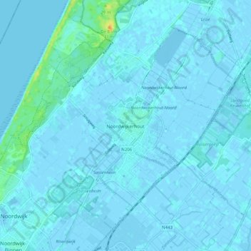
Name: Noordwijkerhout topographic map, elevation, terrain.
Location: Noordwijkerhout, Noordwijk, South Holland, Netherlands (52.23245 4.45268 52.29341 4.53871)
Average elevation: 7 ft
Minimum elevation: -13 ft
Maximum elevation: 89 ft
Dutch topographic map of the municipality of Noordwijkerhout, June 2015
Other topographic maps
Click on a map to view its topography, its elevation and its terrain.
Ruigenhoek
Netherlands > South Holland > Noordwijk > De Zilk > Ruigenhoek
Ruigenhoek, De Zilk, Noordwijk, South Holland, Netherlands, 2191AH, Netherlands
Average elevation: 7 ft
Noordwijk
Netherlands > South Holland > Noordwijk
Noordwijk, South Holland, Netherlands
Average elevation: 3 ft
De Zilk
Netherlands > South Holland > Noordwijk
De Zilk, Noordwijk, South Holland, Netherlands
Average elevation: 7 ft