
Fraser topographic map
Interactive map
Click on the map to display elevation.
About this map
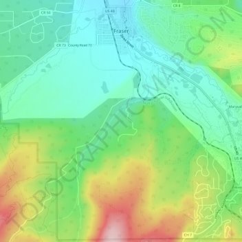
Name: Fraser topographic map, elevation, terrain.
Location: Fraser, Grand County, Colorado, 80442, United States (39.90779 -105.82230 39.95298 -105.77621)
Average elevation: 8,845 ft
Minimum elevation: 8,527 ft
Maximum elevation: 9,475 ft
Fraser is located in southeastern Grand County at 39°56′39″N 105°48′48″W / 39.94417°N 105.81333°W / 39.94417; -105.81333 (39.944158, -105.813355), at an elevation of 8,574 feet (2,613 m) above sea level. It is bordered to the south by the town of Winter Park and to the north by unincorporated Tabernash. U.S. Route 40 leads south and east across Berthoud Pass 71 miles (114 km) to Denver, and northwest 15 miles (24 km) to Granby, the largest town in Grand County.
Other topographic maps
Click on a map to view its topography, its elevation and its terrain.
Morse Mountain
United States > Colorado > Grand County
Morse Mountain, Grand County, Colorado, United States
Average elevation: 9,593 ft
Grand Lake
United States > Colorado > Grand County
Grand Lake, Grand County, Colorado, United States
Average elevation: 8,629 ft
Winter Park
United States > Colorado > Grand County
Winter Park, Grand County, Colorado, United States
Average elevation: 10,066 ft
Lake Granby
United States > Colorado > Grand County
Lake Granby, Grand County, Colorado, United States
Average elevation: 8,556 ft
Granby
United States > Colorado > Grand County
Granby, Grand County, Colorado, United States
Average elevation: 8,383 ft
Rabbit Ears Pass
United States > Colorado > Grand County
Rabbit Ears Pass, Grand County, Colorado, United States
Average elevation: 9,357 ft
Bottle Peak
United States > Colorado > Grand County
Bottle Peak, Grand County, Colorado, United States
Average elevation: 10,771 ft
Elk Mountain
United States > Colorado > Grand County
Elk Mountain, Grand County, Colorado, United States
Average elevation: 10,558 ft
Tabernash
United States > Colorado > Grand County
Tabernash, Grand County, Colorado, 80478, United States
Average elevation: 8,504 ft
Kremmling
United States > Colorado > Grand County
Kremmling, Grand County, Colorado, 80459, United States
Average elevation: 7,385 ft
Mount Flora
United States > Colorado > Grand County
Mount Flora, Grand County, Colorado, United States
Average elevation: 12,231 ft
Indian Peaks Wilderness
United States > Colorado > Grand County
Indian Peaks Wilderness, Grand County, Colorado, United States
Average elevation: 10,105 ft