
Puebla topographic map
Interactive map
Click on the map to display elevation.
About this map
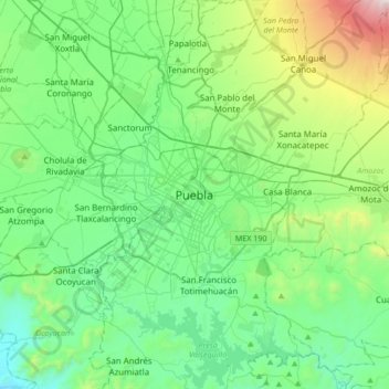
Name: Puebla topographic map, elevation, terrain.
Location: Puebla, Municipio de Puebla, Puebla, 72000, Mexico (18.88372 -98.35847 19.20372 -98.03847)
Average elevation: 7,326 ft
Minimum elevation: 6,001 ft
Maximum elevation: 11,906 ft
Most of its mountains belong to the Sierra Madre Oriental and the Trans-Mexican Volcanic Belt. The first is locally called the Sierra Norte del Puebla, entering the state from the northwest and then breaks up into the smaller chains of Sierra de Zacapoaxtla, Sierra de Huauchinango, Sierra de Teziutlán, Sierra de Tetela de Ocampo, Sierra de Chignahuapan and Sierra de Zacatlán, although these names may vary among localities. Some of the highest elevations include Apulco, Chichat, Chignahuapan, Soltepec and Tlatlaquitepec. The highest elevations are the volcanoes Pico de Orizaba or Citlaltepetl (5,747masl), Popocatépetl (5,452masl), Iztaccíhuatl (5,286masl) and Malinche (4,461masl) which are found on the state's borders with Veracruz, Mexico State and Tlaxcala respectively. In the south of the state, the major elevations are the Sierra de Atenahuacán, Zapotitlán, Lomerio al Suroeste and the Sierra de Tehuacán. Dividing much of the state from Veracruz is a small chain of mountains called the Sierra Madre del Golfo.
Other topographic maps
Click on a map to view its topography, its elevation and its terrain.
Cuexcomate
Cuexcomate, Avenida Miguel Hidalgo, Puebla, 72130, Mexico
Average elevation: 7,021 ft