
Pine River topographic map
Interactive map
Click on the map to display elevation.
About this map
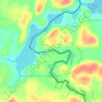
Name: Pine River topographic map, elevation, terrain.
Location: Pine River, Cook County, Minnesota, USA (48.13567 -90.79198 48.13611 -90.78739)
Average elevation: 1,532 ft
Minimum elevation: 1,447 ft
Maximum elevation: 1,644 ft
Other topographic maps
Click on a map to view its topography, its elevation and its terrain.
Lake Vermilion
Lake Vermilion, Frazer Bay Road, Saint Louis County, Minnesota, 55723, USA
Average elevation: 1,398 ft
Ancient River Warren Channel (historical)
Ancient River Warren Channel (historical), Traverse County, Minnesota, USA
Average elevation: 1,027 ft
River Valley
USA > Minnesota > River Valley
River Valley, Pennington County, Minnesota, USA
Average elevation: 1,158 ft
Bde Maka Ska
USA > Minnesota > Minneapolis
Bde Maka Ska, Lake Calhoun Bike Trail, West Calhoun, Minneapolis, Hennepin County, Minnesota, MN, USA
Average elevation: 876 ft
Pomme de Terre Lake
Pomme de Terre Lake, T-205, Grant County, Minnesota, USA
Average elevation: 1,201 ft
Four Corners
USA > Minnesota > Four Corners
Four Corners, Saint Louis County, Minnesota, USA
Average elevation: 1,437 ft
Minnehaha Regional Park
USA > Minnesota > Minneapolis
Minnehaha Regional Park, Hiawatha, Minneapolis, Hennepin County, Minnesota, USA
Average elevation: 817 ft
Como Lake
USA > Minnesota > Saint Paul
Como Lake, Horton Avenue, Saint Paul, Ramsey County, Minnesota, 55103, USA
Average elevation: 919 ft
Montrose Manor Mobile Home Park
USA > Minnesota > Montrose Manor Mobile Home Park
Montrose Manor Mobile Home Park, Wright County, Minnesota, 55363, USA
Average elevation: 968 ft
Sand Prairie WMA
USA > Minnesota > Clear Lake
Sand Prairie WMA, US 10, Clear Lake, Sherburne County, Minnesota, 56304, USA
Average elevation: 1,037 ft
Lake Carlos
USA > Minnesota > Hiview Park
Lake Carlos, East Lake Carlos Drive Northeast, Hiview Park, Douglas County, Minnesota, 56319, USA
Average elevation: 1,381 ft
Point Douglas
USA > Minnesota > Point Douglas
Point Douglas, Washington County, Minnesota, WI - 54021, USA
Average elevation: 751 ft
Okamanpeedan Lake
Okamanpeedan Lake, 17th Street, Wilbert, Martin County, Minnesota, 56121, USA
Average elevation: 1,243 ft
Heron Lake
USA > Minnesota > Heron Lake
Heron Lake, Jackson County, Minnesota, 56137, USA
Average elevation: 1,417 ft
Merden Lake
USA > Minnesota > Jacobs Prairie
Merden Lake, County Road 160, Jacobs Prairie, Stearns County, Minnesota, 56374, USA
Average elevation: 1,181 ft
Swollen Ankle Lake
Swollen Ankle Lake, Forest Rt 1344, Cook County, Minnesota, USA
Average elevation: 1,821 ft
Zippel Bay
Zippel Bay, Bay Drive Northwest, Lake of the Woods County, Minnesota, 56686, USA
Average elevation: 1,060 ft
Lake Cornelia
Lake Cornelia, Edina, Hennepin County, Minnesota, 55435, USA
Average elevation: 883 ft
Greenleaf Lake
Greenleaf Lake, 640th Avenue, Greenleaf, Meeker County, Minnesota, 55324, USA
Average elevation: 1,099 ft
Ojibway Park
Ojibway Park, Woodbury, Washington County, Minnesota, USA
Average elevation: 1,024 ft
Mystery Cave State Park
Mystery Cave State Park, Etna, Fillmore County, Minnesota, USA
Average elevation: 1,316 ft
Spring Park Bay
Spring Park Bay, Wilshire Boulevard, Mound, Hennepin County, Minnesota, 55364, USA
Average elevation: 938 ft
Wenonah
USA > Minnesota > Minneapolis
Wenonah, Minneapolis, Hennepin County, Minnesota, USA
Average elevation: 837 ft
Split Rock Lighthouse
Split Rock Lighthouse, Superior Hiking Trail, Lake County, Minnesota, USA
Average elevation: 666 ft
Springbrook Nature Center
Springbrook Nature Center, Fridley, Anoka County, Minnesota, USA
Average elevation: 876 ft
Temperance River
Temperance River, Cook County, Minnesota, USA
Average elevation: 1,870 ft
Westwood Hills Nature Center
USA > Minnesota > St. Louis Park
Westwood Hills Nature Center, Westwood Hills, St. Louis Park, Hennepin County, Minnesota, USA
Average elevation: 915 ft
Hiawatha
USA > Minnesota > Minneapolis
Hiawatha, Minneapolis, Hennepin County, Minnesota, USA
Average elevation: 817 ft
Keewaydin
USA > Minnesota > Minneapolis
Keewaydin, Minneapolis, Hennepin County, Minnesota, 55417, USA
Average elevation: 837 ft
Judge C. R. Magney State Park
Judge C. R. Magney State Park, Cook County, Minnesota, USA
Average elevation: 1,145 ft
LaSalle Lake
LaSalle Lake, CR 9, Becida, Hubbard County, Minnesota, 56678, USA
Average elevation: 1,473 ft
Big Basswood Lake
Big Basswood Lake, Sockeye Lake Road, Becker County, Minnesota, 56575, USA
Average elevation: 1,572 ft
Tamarack Nature Preserve
Tamarack Nature Preserve, Woodbury, Washington County, Minnesota, USA
Average elevation: 1,030 ft
Clearwater River
Clearwater River, Meeker County, Minnesota, 55389, USA
Average elevation: 1,158 ft
Little Pine River
Little Pine River, Crow Wing County, Minnesota, USA
Average elevation: 1,234 ft
Atkinson Lake
Atkinson Lake, 608th Avenue, Greenleaf, Meeker County, Minnesota, 55355, USA
Average elevation: 1,102 ft
Howe
USA > Minnesota > Minneapolis
Howe, Minneapolis, Hennepin County, Minnesota, 55406, USA
Average elevation: 823 ft
Saint Louis Bay
Saint Louis Bay, Courtland Street, Duluth, Saint Louis County, Minnesota, 55806, USA
Average elevation: 610 ft