
Peñacerrada-Urizaharra topographic map
Interactive map
Click on the map to display elevation.
About this map
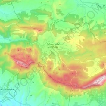
Name: Peñacerrada-Urizaharra topographic map, elevation, terrain.
Average elevation: 2,516 ft
Minimum elevation: 1,463 ft
Maximum elevation: 4,475 ft
Other topographic maps
Click on a map to view its topography, its elevation and its terrain.
Soil
Spain > Autonomous Community of the Basque Country > Montaña Alavesa/Arabako Mendialdea
Soil, Arraia-Maeztu, Montaña Alavesa/Arabako Mendialdea, Álava, Autonomous Community of the Basque Country, 01207, Spain
Average elevation: 2,946 ft